https://pagead2.googlesyndication.com/pagead/js/adsbygoogle.js?client=ca-pub-5023777017943172
UPDATED DECEMBER 2020. I have just published a 60 minute documentary on my Puranic Geography research! It has been uploaded in two parts:
The Puranic Geography of Bhārata-varsha
~
The Geo-Sphere vs. The Flat Earth
AC Bhaktivedanta Swami (Śrīla Prabhupāda) who was the first successful pioneer to transplant the teachings of Krishna within the western world, requested his disciples to construct a planetarium based on the descriptions of the universe given in the fifth book of the Śrīmad Bhāgavata Purāṇa. He advised them to also study the other Purāṇas, Samhitas and other literature of the Vaishnava tradition to clarify and shed light on a working model of our universe. It was also Śrīla Prabhupāda’s style to often express ancient terminology with modern phrases and concepts to help the common man understand the complexities of Vedic Cosmology. It is with his blessings and within these basic guidelines that the following analysis of Bhāgavata and Puranic geography will be presented.
Information posted here are excerpts from my upcoming new book which researches the ancient geography and cosmology of the texts known in India as “Purāṇas” or “The Old Histories”. It will also serve as a platform to share the Purāṇic text resources in PDF format, and to share some of my new maps based on the recently translated sections of this ancient literature.
Delving into the major purāṇas and epics of India, we will examine what landforms and modern countries fall within the boundary of the region called Bhārata-varṣa. We will demystify the apparent contradictions in the definition of ‘Bhārata’ as both the Indian continent and as the Earth, compare the Purāṇic map of the Jambūdvīpa island with maps of our known world, identify the regions referred to as the nine islands of Bhārata and the eight upa-dvīpas, or ancillary islands of Jambūdvīpa, and finally, create a map of Bhārata that best represents the description given in the Śrīmad Bhāgavatam.
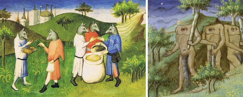
Illustrations from a 12th century European travel guide to the east!
Section 1 – Resources
The Geographical Sections of the major Puranas in English PDF format.
For quickest download, right click and choose “save link as” to your own download folder. They mostly range from 2 to 20 Mb. The numbers in brackets refer to the relevant chapters of each Purāṇa, and the Roman numerals, the relevant canto or section.
Agni Purana (Cosmography 108-120)
Brahma Purana (Cosmography 16-26)
Brahmanda Purana (Cosmography 14-20)
Brahma Vaivarta Purana (Cosmography 7-9)
Devi Bhagavata Purana (Cosmography 11-12)
Garuda Purana (Cosmography 54-58)
Harivamsa Cosmography 61-62)
Kurma Purana (Cosmography 45-50)
Linga Purana (Cosmography 45-53)
Markandeya Purana (Cosmography 53-60 Dutt)
Markandeya Purana (Cosmography 54-60 Pargiter)
Matsya Purana (Cosmography 114-121)
Narada Purana (Cosmography 3 Math 54)
Nilamata Purana (Geography v601-622)
Padma Purana (Cosmography III.3-9)
Shiva Purana (Cosmography III.8-22)
Skanda Purana (Cosmography I.II.37-40 Bharata VII.I.172)
Vamana Purana (Cosmography11-13)
Varaha Purana (Cosmography 63-102)
Vayu Purana (Cosmography 32-53 Sharma)
Vayu Purana (Cosmography 32-53 Tagare)
Vishnudharmottara Purana (Cosmography 3-23)
Vishnu Purana (Cosmography II.1-6 Wilson)
Vishnu Purana (Cosmography II.1-4 Wilson)
other texts:
Virodhamadana by Yajñeśvara Śarmā
Geography & Customs of India (300 BC Megasthenes-Arrian)
Siddhanta-Siromani (Bharata’s Khandas)
Manusmriti (Aryavarta & Brahmavarta)
Siddhanta-Siromani (Arkasomayaji)
Surya-Siddhanta (Sastri) Siddhanta-Siromani (Wilkinson)
Nine Divisions of Bhārata Varsha (Varahamihira)
Kurma Vibharga from Skanda Purana
Bhugola Varnanam by Sri Vädiräja Tirtha
The above documents are each a pdf extract of the geography and cosmology chapters of the major Purāṇas, which can be downloaded in full from the Internet Archive Digital Library here
I strongly encourage those interested in my latest research about Bhārata-varṣa, to read my new 20 page Preview of the upcoming book “The Purāṇic Geography of Bhārata-varṣa” here. It contains an additional 100 page appendix of essential side-notes, original Purāṇic slokas, and transcripted conversations by Śrīla Prabhupāda, recorded only months before he physically left our world in 1977, all about his vision of Bhū-mandala, Jambudvipa and Bhārata-varṣa, and the importance of presenting the original Sanskrit Purāṇic descriptions over and above the modern atheistic theories of “Scientism”. This preview ‘summary’ has new material that is complementary to the excerpts already provided on this web-page.
Also below, is a recent 5-minute Australian TV interview (March 2019) with Mark Sargent posted on Facebook outlining some common scientific reasons why so many people have revived the ancient concept of a Flat Earth reality ……….

Today Show – 26th March 2019 – Flat Earth
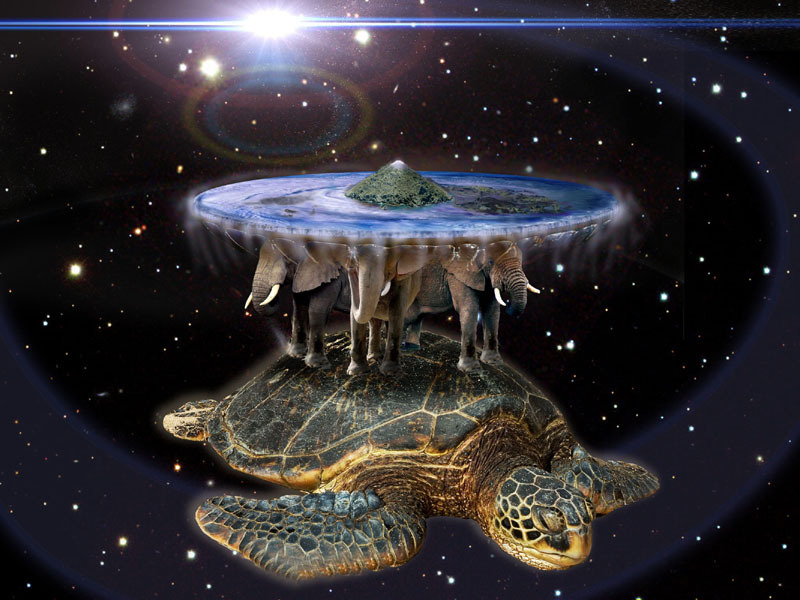
Fantasy art from ‘Discworld’ based on Purāṇic cosmology
Gallery: Maps of the ‘Earth Circle’ and ‘Mt Meru’ from Various Traditions


One of my first blogs on this ‘ancient wisdom’ website, was a page dedicated to the Vedic model of the universe. From several different documentaries created by the Hare Krishna scholars of America, Britain and India, I edited together a 20 minute educational 3D animation called “Tour of Our Vedic Universe and Beyond“.
Since then, seven more years of research has revealed details of how our planet Earth fits into the Vedic, or Purāṇic, model of the cosmos. Both a deeper study of the Purāṇic and Jyotish texts, plus a world-wide re-emergence of interest in the flat-Earth model, has created an opportunity for me to re-examine and fine-tune my presentation of the Vedic Universe.
Amongst the current deluge of both Youtube information and dis-information, surprising evidence has emerged which discredits the standard formula for viewing the curvature of the Earth. Similar scientific tests repeated over recent years now support the scriptural statements from many traditions, that Earth occupies a special central place in the cosmos. Fake news, fake photos and fake videos of astronauts and the Earth from space are being seen for what they are – fundraising propaganda for government agencies like NASA, …. and these ideas are all lining up with new verses found in the ancient puranic texts, now available for download at the top of this page.
Discussion: An Overview of the Geographical Content of the Major Purāṇas
The assessment of the cosmographical content of the Purāṇic texts warrants many considerations. Although we have the authority of the Śrīmad Bhāgavata Purāṇa along with the unbroken lineage of Bhāgavata custodians since the advent of Bhāgavan-Śrī-Caitanya-deva – who all testify to the pastime of Śrīla Vyasadeva writing down the major and minor Purāṇas along with the Mahābhārata immediately prior to the beginning of Kaliyuga some 5,000 years ago, the purāṇas themselves describe by which orator and in which kalpa each are originally composed.
Due to the mystical and transcendental nature of the authors, histories can be retold from any of the 18,000 kalpas since the morning of the first day of the first year of Brahma’s life. Many Puranic references substantiate we are presently in the 51st year of Brahma’s creation. Other stories are envisioned from future kalpas, from any of the 50 remaining years of Brahma’s life. During each year of Brahma’s life, 360 kalpas and Earth devastations pass away, and during each kalpa passes 1,000 Mahayuga-cycles, consecutively ruled by 14 Manvantaras or ‘Manus’.
Review the concept of the repeated cycle of four Yugas, or Cosmic Ages, here.
Since our acaryas have stated that Śrī Krishna and Śrī Chaitanya appear only once in each day of Brahma, thus the present kalpa within the last 5,000 years, it is obvious that histories of Krishna – and subsequently many histories and geographies of Bhārata-varṣa mentioned in the Purāṇas – refer to pastimes in previous kalpas. Those purāṇic slokas which list when each purāṇa was originally composed should be especially referenced to explain differences in Bharata genealogies and geo-political boundaries, viz. Bhārata-varṣa’s khandas and dvipas.
In those Purāṇas, there are several lists of the names of the 30 kalpas (days of one month of Brahma) and in which kalpas the different purāṇas are composed. The days of Brahma’s month are not identical, being named from various events or avatars manifesting in each day. Thus, differences in geography arise not only in different months of kalpas, but also by the passing of each kalpa, and by the passing of yuga cycles. Fortunately, during each morning of Brahma’s day [kalpa], the eleven lowest worlds, which are demolished by fire and water, are recreated almost identically, as a material reflection of Goloka Vrindavan’s original landscape. The samskar of Brahma’s enlightened vision by Śrī Govinda-deva serves as the daily impetus to recreate the worlds.
Similarly, by the power of transcendental vision, previous purāṇas may accurately describe the future situation of Bhārata-varṣa, as it may apply to the world of this present Mahāyuga of this present Varāha kalpa. These different perspectives on the historical and geographical content of the purāṇas should be understood at the beginning of any comparative study of Purāṇic literature.
This consideration is completely separate to the issue of accurately copying the Sanskrit texts over generations of Guru-disciple lineage. The other major consideration is the accurate translation of the surviving Sanskrit manuscripts into the English language. As we progressively post excerpts from “Purāṇic Geography of Bhārata-varṣa”, our team of translators and advisers will help to maintain the integrity of the geographical descriptions of the Purāṇic Earth as envisioned by the ancient seers.
Section 2 – Contents
Introduction
Kalpa-Bheda and the Purāṇas
Defining the Bhārata-varṣa of Jambūdvīpa
The Division of Bhārata-varṣa into Nine Khaṇḍas
The Islands in the Ocean Associated with Bhārata-varṣa
The “Hare and Fig-tree” Geography of the World
The Lotus, Sāṅkhya, and the Fourth Dimension
New Purāṇic Maps of Bhārata-varṣa
Appendixes
~
To date, December 2020, only the summary of four chapters have been posted. More recent information is provided in the book ‘Preview’ – please follow this link here. Most of 2019 has been spent re-analyzing the Sanskrit verses from several Puranas – the evidence required to create a more accurate map of our Earth-realm known as Bhārata-varṣa. Additional research from my still unpublished book can be read in Puranic Geography Part 2.
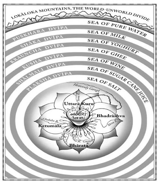
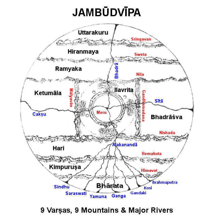
According to all the Purāṇas, the golden Mount Meru rises in the centre of the heavenly island of Jambūdvīpa, which is at the center of the universal plane of Bhu-mandala. The entire Earth is located on the southern shore of Jambūdvīpa.
1. Defining Jambūdvīpa and Bhārata-varṣa
Modern science currently estimates the Earth to be a sphere 8,000 miles in diameter which spins at 1,000 mph, while orbiting the sun at 67,000 mph, simultaneously orbiting the galaxy at a greater speed. The Indian Himālayas are seen to have an average height of nearly 4 miles and stretch for a length of about 1,400 miles. The sun and moon, though said to be vastly different in size, and vastly different in distance, appear exactly the same size to us, and appear to rise and set over the horizon.
The Purāṇas describe the Himalayas have a maximum length of 640,000 miles and a height of up to 16,000 miles. How does the world of the Purāṇas translate to the world that we inhabit and experience through the senses of our everyday lives? The Purāṇic Earth is said to be flat, fixed and immobile, beneath a revolving sky of stars, the moon and the sun. While this matches our everyday experience, the scientists present the teachings that we are helplessly flying through the galaxy at 490,000 miles per hour, and that by some unimaginable coincidence, the centrifugal force created by all this motion is perfectly balanced by a force that nobody can explain, called gravity. What a convenient outcome for an explosion that came out of no-where, for no reason, and which also ignores every known law of nature!
Such dilemmas have been answered in the ancient pages of the Purāṇas. They contain the histories of the world, creation stories, the stories of great kings and saints, and how the incarnations of Godhead have appeared amongst us over the millenniums. They contain knowledge of astronomy, astrology, architecture, medicine, surgery, poetry, music, politics, laws, geography, and the different religious and philosophical pathways to self-realization. They have been passed down since time immemorial as memorised verses, guarded by the succession of Masters and students, and were written down for our benefit around 5,000 years ago.
The Earth as a cosmic petal of the lotus of the Universe
In attempting to describe the arrangement of the universe, Śrī Śukadeva, the guardian of the Bhāgavata Purāṇa, says this: “My dear King, there is no limit to the expanse of the Supreme Lord’s material energy. This world is simply the transformation of the three material qualities, yet no one could possibly explain it perfectly, even in a lifetime as long as that of Brahma” (SB 5.16.4) i.e.: 3.14 x 10¹⁴ years. And in the Brahmaṇḍa Purāṇa, Śrī Suta explains “Men mention the magnitude of the cosmos by means of guess alone. One cannot arrive by means of guess alone, at those things which cannot be pondered upon. That which is beyond nature is called Achintya (that which is inconceivable)”. (B.P. 15:7-8).
The contents of this chapter examines how the term Bhārata-varṣa has been simultaneously applied to the subcontinent of India, to the complete Eurasian landmass, and to include the whole Earth as we know it, in both the Śrīmad Bhāgavatam and many other Purāṇic scriptures. It describes how this world we live in goes through cosmic cycles of time where floods, Ice Ages and Golden Ages affects the shape and size of the world, and the consciousness of both past and future civilizations. This chapter also maps out the mysterious border regions which connects our world to other realms, known as Jambūdvīpa and Sumeru in Hindu, Buddhist and Jain traditions, and to realms of the Sacred Isles, Arcadia, Asgard, Avalon, Eden, Olympus, and Shambala in other traditions.

Apsara Nymphs in the pleasure gardens of Meru
2. The Division of Bhārata-varṣa into Nine Khaṇḍas
Often the Purāṇas describe 5 divisions of the kingdom of Bhārata, namely, the middle province and those of the four cardinal points, as does the Mahabharata. Some Purāṇic descriptions add the mountain regions of the Vindhyas and the Himālayas, along with their rivers, creating 7 regions. However, the division of Jambudvīpa into 5, 7 or 9 petals is often confused with the division of Bhārata-varṣa into 5, 7 or 9 divisions. There is a good reason for this, as the transcendental template of creating the universe in the shape of a lotus is repeated, just like the fractal repetition found everywhere in nature.
This lotus pattern expands from the original vision of Goloka Vrindavan, to the outer petals of Mathura, Dwarka and Ayodhya, to the expansion of Vaikuṇtha planets, to the expansion of universes from Mahaviṣṇu, to the creation of the lotus of the 14 worlds, to the creation of the lotus of Bhū-mandala (where Lokāloka Mountains are the boundary petals), to the lotus of Jambūdvīpa (where the Varṣa-Parvata’s are the petals), to the lotus of Earth (which acts like a closed karma lotus bud with Meru at the poles), to the lotus of Eurasia (where the Pamir Mountains represent Meru), and finally to the lotus of Greater India, where Manu’s Brahmāvarta is at the centre, surrounded by eight petals, which are the geographic regions in the eight directions, sometimes called the nine dvīpas or khaṇḍas.
This description of Bhārata as ‘India’ is found in every single Purāṇa, and is called ‘Puṇya Bhūmi’, the ‘Land of Seven Rivers’, the land of seven ‘kula-parvata’ mountains, the ‘land of Nava-Khaṇḍas’, or ‘Nava-dvīpas’, which are in the eight directions described by the astronomers Parasara and Varāhamihira. According to this arrangement, Panchala was the chief district of the central division, Magadha of the east, Kalinga of the south-east, Avanta of the south, Anarta of the south-west, Sindhu-Sauvira of the west, Harahaura of the north-west, Madra of the north, and Kauninda of the north-east. The list from Varāhamihira’s abstract are in the same order as the Markaṇḍeya Purāṇa.
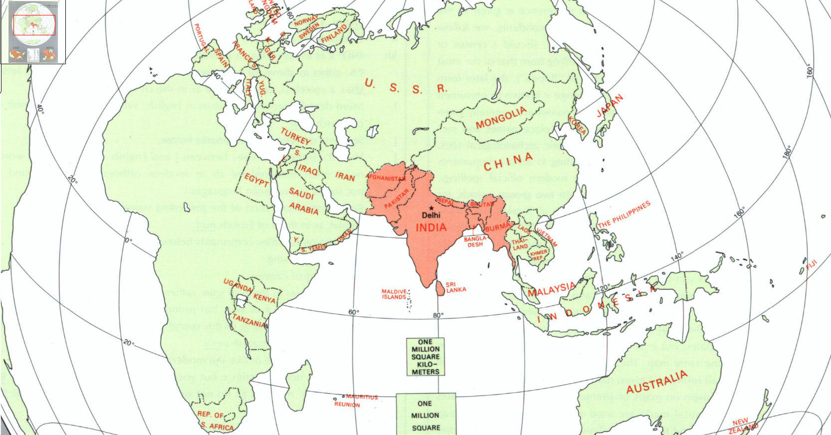
Bharata-varsa as the Indian subcontinent, which was at the centre of the ancient world
By comparing the detailed lists from works like the Brihat-Samhita or the Siddhanta-Siromani, with those of the Brahmanda, Markandeya, Vishnu, Vayu, and Matsya Purāṇas ; we find that, although there are sundry repetitions and displacements of names, as well as many various readings, all the lists are substantially the same. Although most Purāṇas mention the Nine Divisions and give their names, only the Brahmanda, Markandeya and Skanda state the names of the districts in each of the Nine Divisions. They follow the same order in all ; namely, Indradvīpa, Kaśeru, Tāmradvīpa, Gabhastiman, Nāga, Saumya, Gāndharva, Varuṇa and Kumārikā. No description is given to identify these names, but they mention Indradvīpa to be in the east, Varuna in the west, and Kumarika in the middle.
Unfortunately to date, these divisions without description, have made them difficult to locate, as parts of India, or as parts of the known world, or as places where humans reside that we have no knowledge of. That these ‘dvīpas’ might be unknown worlds of humans lying beyond the extent of either the Flat-Earth’s Antarctic ice-ring, or beyond the stationary Earth-Globe sitting on the ocean, are the two most common speculations held by most ISKCON Vedic cosmology researchers today.
The Nine Khaṇḍas of Bharata were often thought to be islands in the ocean
However, by careful study of the Purāṇic literature, the key to identifying these Nava-dvīpas of Bhārata has finally been revealed. Below are compared the usual translations about the nine dvīpas, with some new and very revealing verses from lesser studied Purāṇas:
Vishnu Purāṇa (quoted in Śrīmad Bhagavatam 5.19.19, comments by Srila Visvanatha Cakravarti Thakura)
Listen to the nine divisions of Bhārata-varṣa. They are Indradvipa, Kaśeru, Tāmravarna, Gabhastimant, Nagadvipa, Saumya, Gāndharva, Vāruṇa, and the ninth [Navadvipa], which is situated near the ocean in the midst of the other eight islands [“sagara saṁvṛita” means situated in the proximity of the sea*]. It extends 1,000 yojanas from north to south. To the east, the Kirata’s live and to the west are the yavanas. [In the east of this island there are the denizens of Kamarupa (Assam). Odhas, Kalingas and Magadhas are all the denizens in the south.] (VP 2.3.6-9)
*Note that the acarya Srila Visvanatha translates sagara-saṁvṛta as ‘in the proximity of the sea’ and NOT ‘separated by the ocean’, as the latter is often how the Sanskrit is rendered to English in many other Puranas which duplicate this verse. Here also the ninth division ‘navadvipa’ is unmistakably identified with India extending 1,000 yojanas from the ocean to the Himalaya. Therefore, in this interpretation, Bharata-varsa must equal the entire Eurasian landmass, of which the Indian peninsular is a ninth portion.
Siddhānta-śiromaṇi (Golādhyāya, Bhuvana-kośa, Ch 3 verse 41-42)
“Within Bhārata-varṣa, there are nine khaṇḍas. They are known as (1) Aindra, (2) Kaśeru, (3) Tāmraparṇa, (4) Gabhastimat, (5) Kumārikā, (6) Nāga, (7) Saumya, (8) Vāruṇa and (9) Gāndharva. In the Kumārikā alone is found the subdivision of men into castes, in the remaining khaṇḍas are found all the tribes of Antyajas or outcaste tribes of men. In this region [Bhāratavarṣa] are also seven Kriachalas (mountain ranges). The Mahendra, Sukti, Malaya, Rishika, Pāriyātra, Sahya and Vindhya hills.”
This list places the previously un-named dvīpa of Kumārikā in the middle. More importantly, these verses describe the divisions as Khaṇḍas (literally ‘divisions’ or ‘sections’) and are associated with, or separated by, the famous seven mountain ranges of Bhārata. This is a completely different picture …. that the “islands” are divisions of the land south of the Himālayas and surrounded by the ocean, the most important and central being Kumārikā-Khaṇḍa. This next verse from the Bhagavata Purāṇa indicates that the Sanskrit term ‘dvīpa’ is often applied to regions separated by mountains, rivers and forests …. not by oceans. “To stop the quarreling among different peoples, Mahārāja Priyavrata marked boundaries at rivers and at the edges of mountains and forests so that no one would trespass upon another’s property.” (SB 5.1.40) Bhaktivedanta Purport: “The example set by Mahārāja Priyavrata in marking off different states is still followed. As indicated here, different classes of men are destined to live in different areas, and therefore the boundaries of various tracts of land, which are described here as islands, should be defined by different rivers, forests and hills.”
Vāyu Purāṇa (45.78-82)
There are nine islands attached to Bhārata-varṣa, separated by the ocean. One cannot go to one island from another. They are Indradvīpa, Kaśeru, Tāmraparna, Gabhastiman, Nāgadvīpa, Saumya, Gāndharva, Vāruna and Bhārata itself the ninth. Bhārata-varṣa is one thousand yojanas from south to north, extending from Kanyākumārī in the south to Gangotri in the north. From east to west it is 9,000 yojanas, Mlecchas reside always near and beyond the borders of this varṣa. To the east there are Kirātas and to the west there are Yavanas.
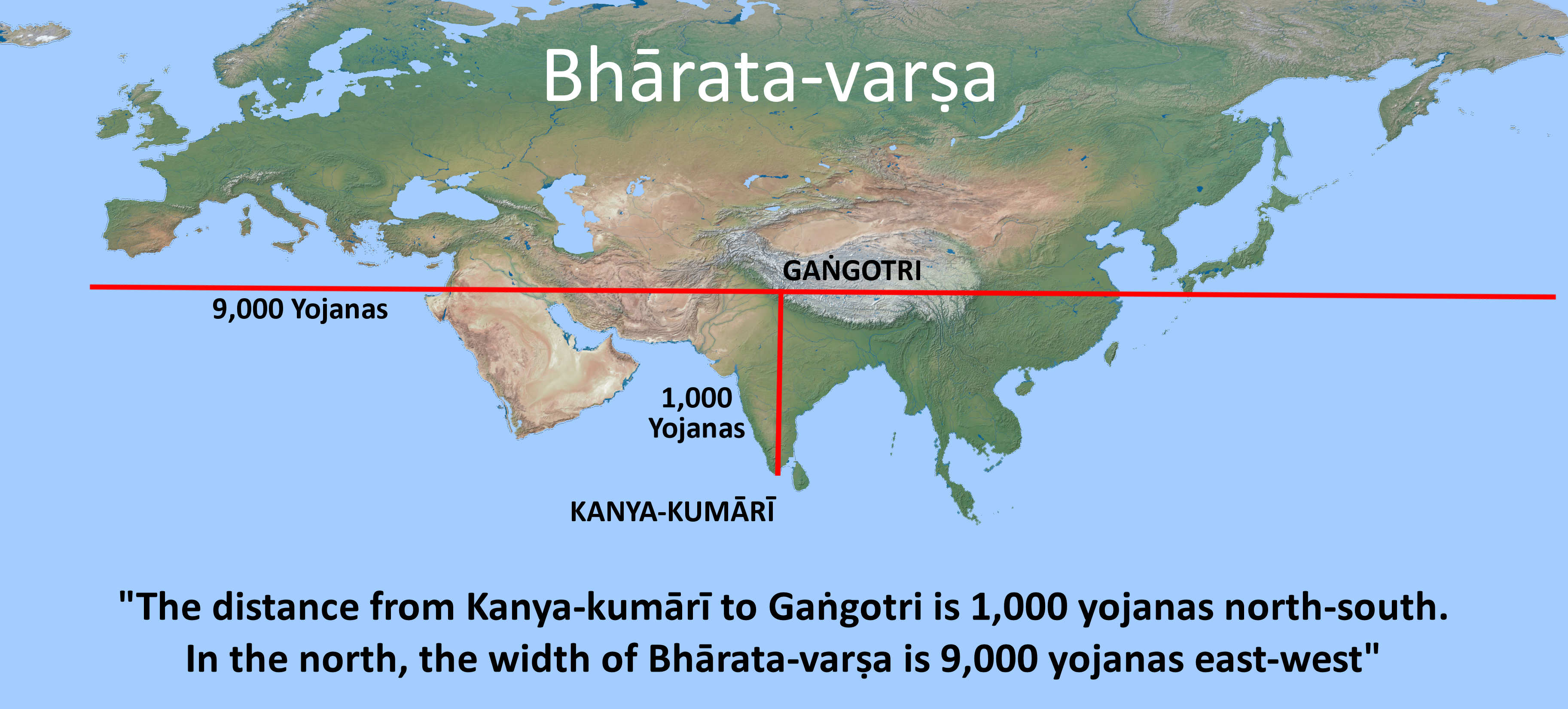
These measurements repeated in many Purānas indicate a value of the yojana to be approx 1.5 miles. This identifies Bhārata with the continent of Eurasia.
Bhāgavata Purāṇa (translated by Śrīla Prabhupāda)
In regard to “attached to Bhārata-varṣa”, the Śrīmad Bhāgavatam also lists eight islands, but we are given a completely different list: “The names of these islands are Svarṇaprastha, Candraśukla, Āvartana, Ramaṇaka, Mandara-hariṇa, Pāñcajanya, Siṁhala and Laṅkā. My dear King Parīkṣit, O best of the descendants of Bharata Mahārāja, I have thus described to you, as I myself have been instructed, the island of Bhārata-varṣa and its adjoining islands.” (SB 5.19.30-31)
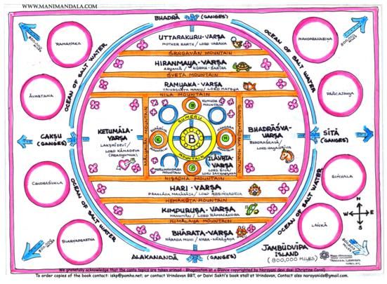
Jambūdvīpa divided into nine varṣa-realms and surrounded by eight islands called ‘upadvīpas’
We can see listed here a different type of island. These ‘upadvīpas’ – the Sanskrit word used, do not claim to be divisions of Bhārata-varṣa at all, but rather additional islands in the ocean surrounding Jambūdvīpa in the vicinity of Bhārata. Siṁhala and Laṅkā are well known to us, but the others have no description, however, the upadvīpas are given extensive description in the 48th chapter of the Vāyu Purāṇa. By cross-examination we can identify several of those listed in the Bhāgavata, but the names and details given in the Vāyu are descriptive enough to identify with the known islands and continents of the Earth. Thus, this distinction between upadvīpas and the navadvīpas (nine khaṇḍas) should remain very clear in subsequent maps of Jambūdvīpa and Bhārata-varṣa. The major upadvīpas, 13 of which have been named in the Vāyu Purāṇa, is the subject matter of the next chapter of “Purāṇic Geography”.
Agni Purāṇa (Ch 118 v1-5):
“1. That country which (lies) to the north of ocean and south of Himadri (Himalaya) is known as the Bhāratavarṣa extending to nine thousand (yojanas) 2-4. This is a land of religious rites. It gives accomplishment of action in getting redemption. Mahendra, Malaya, Sahya, Suktimat, Hemaparvata, Vindhya and Pariyatra are the seven principal mountains here. Indradvīpa, Kaśeru, Tāmravarṇa, Gabhastimān, Nāgadvīpa, Saumya, Gāndharva, Vāruṇa and Bhārata are the nine territories here surrounded by the ocean. 5. The continent extends to one thousand yojanas from north to south. There are nine divisions of the Bhārata lying around the central part with the Kiratas in the east and the Yavanas in the west.”
Here, the subtle difference in rendering to English envisages a regional division of India surrounded by ocean, the exact opposite of the typical “each surrounded by ocean” rendering. Once again the whole of Bhārata is recognised by the same seven mountains and their respective rivers.
Mārkaṇḍeya Purāṇa (54:5-6 & Ch 55)
“Surrounded by the ocean are the nine divisions in Bhārata-varṣa – all of them are mutually inaccessible. They are Indradvīpa, Kaśeru, Tāmraparṇa, Gabhastimān, Nāgadvīpa, Saumya, Gāndharva, and Vāruṇa.”
At the beginning of chapter 55 (or chapter 58 in some editions), Kraushtaki requests to hear about how Lord Hari resides in Bhāratavarṣa in his Kūrma form. Mārkaṇḍeya replys: Kūrma occupies the entire Bhārata-varṣa with its nine divisions. His head faces the east. All the stars and other things occupy the different divisions of his nine fold divisional body.”
The chapter describes all the kingdoms in the nine divisions of Bhārata, and the following summary clearly demonstrates that the nine so-called “dvīpas” of Bhārata are actually nine divisions of the Indian subcontinent: (1) the middle portion, including the Sārasvatā, Panchala and Aravali Hills (Pāriyātra), (2) the head (east) portion, including Māgadha, Lohitya and Kosala, (3) right foot (south-east) portion, including Kalinga, Andhra and Vidarbha, (4) right side (south) portion including Maharashtra, Karnataka, Kāverī river, Malaya Mts, Siṁhala and Laṅkā. (5) right hind foot (southwest) portion including Pahlava, Indus river and Saurashtra. (6) tail (west) portion including Tarakshuras (Iran), Asta-giri (Afghanistan) and Panchanada (Punjab). (7) Left hind foot (north-west) portion, including Asvaka-Kambhojas, Bāhlikas (Bactria) and Kandahar (8) left side (north) portion including Kailash, Himālayas, Kashmir, Takṣaśilā (Taxila), Huns (Tibet) and Rasalaya (Lhasa). (9) north-east foot portion, including, mountainous villages of Kiratas, Yavanas and Pauravas, the Koshi River (Nepal) and Vana-rastra (Assam). These are all located on the map below.
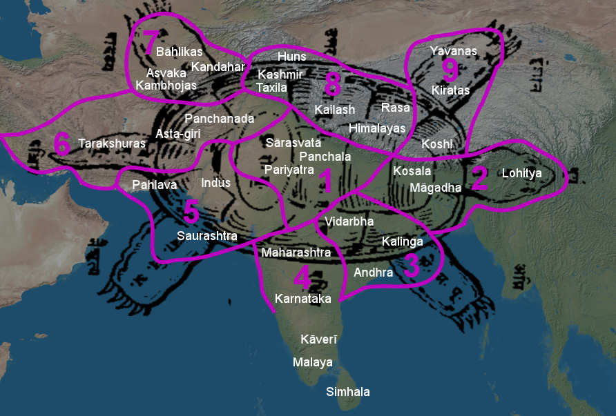
The Kūrma-vibhāga, or nine-fold division of Bhāratavarṣa – in the shape of a tortoise, from the 55th chapter (sometimes 58th) of the Mārkaṇḍeya Purāṇa.
Skanda Purāṇa (Maheśvara Khaṇḍa, Book 2, Chapter 39)
While the Mārkaṇḍeya Purāṇa accurately locates the nine khandas of Bhārata in the world, the largest Purana amongst them all is the only one that gives the origin of these nine names. The Skanda Purāṇa gives the story of how these divisions get their names, and how Kumarika-devi donated her portion to her brothers, Indradvīpa, Kaśeru, Tāmravarna, Babhasimān, Nagadvīpa, Saumya, Gāndarva, Vāruṇa. Next she divides up each ‘Khaṇḍa’ or ‘Dvīpa’ into a further eight parts, and states the number of villages in each of them. This results in a list of 72 regions that span Southern Asia, or the Greater India called “Bhārata-Khaṇḍa”. Below are these important verses from the 39th Chapter.
“Śrī Nārada said : There was one named Ṛṣbha whose name, O son of Pṛtha, will be associated with many heretic concepts and views in Kali Yuga [Jainism]. They will be contributory to the delusion of all the worlds. Bharata was his son. Śataśṛṅga was his son. Eight sons and a daughter were born to him. They were Īndradvīpa, Kaśeru, Tāmradvīpa, Gabhastiman, Nāga, Saumya, Gāndharva and Varuṇa. The girl’s name was Kumārikā.
He [King Śataśṛṅga] divided this Bhārata continent into nine regions. Eight of them he gave to his [eight] sons and the ninth one to Kumārī. I shall describe the different regions rendered splendid by the mountains. Listen from me to the mountains and the sub- continents named after the sons. Mahendra, Malaya, Sahya, Śuktimān, Ṛkṣaparvata, Vindhya and Pāriyātra – these seven are the chief mountains.
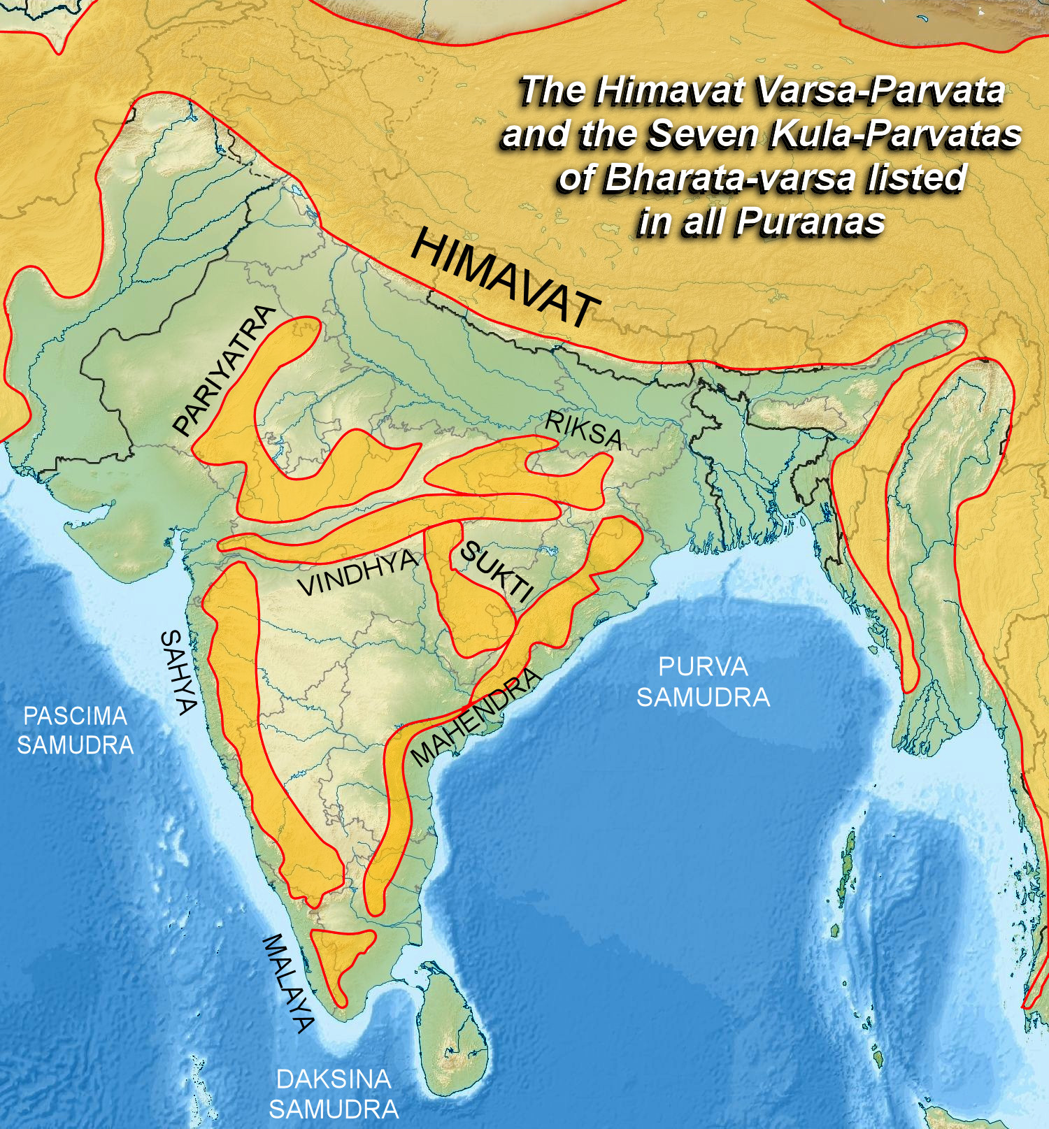
These are the seven mountain ranges that define the location of Bhārata-varsa in every single Purāna: Pariyatra, Riksha, Vindhya, Suktimat, Mahendra, Malaya and Sahya Mountains. Their locations can be confirmed by the rivers that still flow from them today, as many have retained their ancient names.
Indradvīpa is said to be beyond Mahendra. The sub-continent of Kumārika is said to be located on the lower slopes of Pāriyātra. Each of these regions extends to a thousand (Yojanas). After dividing the kingdom thus among his sons and the daughter Kumārī, the king Śataśṛṅga went to the mountain in the north and performed penance. The magnificent virgin Kumārī of exalted fortune stayed at Stambhatīrtha. With the wealth coming from her sub-continent, she performed the rites of giving in charity and austere penance. After some time, nine sons of great vigour, strength and zeal were born to each of those eight brothers. They gathered together, approached Kumārī and spoke (thus): “O splendid lady, you are our family goddess. Be pleased with us. Divide these eight sub-continents into seventy-two regions yourself, and give them to us so that there will be no difference (discord) amongst us.”
The Virgin Goddess Kumārī-devi who divided up the nine khandas of Bharata-varsa into 72 kingdoms.
On being asked thus, she who was conversant with all righteous acts and pious duties and who was on a par with Brahma in wisdom and knowledge, divided the nine continents into seventy-two regions. I shall truthfully tell you, 0 Phālguna, their names, the villages, towns, shores and banks and their number.”
The text goes on to describe 72 regions, and even how many towns and villages were in each kingdom, for example: – “There are 100,000 villages in Nepāla [Nepal], Bālāka [Kazakhstan] is said to be a country with 25,000,000 villages. There are 7,200,000 villages in Gajaṇaka [Afganistan], There are 1,800,000 villages in Gauḍa Deśa [West Bengal], 900,000 villages are well-known in Kāmarūpa [Assam] In the Oḍḍiyāṇa [Orissa] country 900,000 (villages) have been declared. Similarly, 900,000 (villages) have been declared in Jālandhara land [Jharkhand]. Bālhika [Bactria] is known as having 400,000 villages. Laṅkā Deśa is known as having 36,000 villages, Kāśmīra Maṇḍala is said to have sixty-eight thousand, etc. etc. etc. ….. Thus in Bhāratakhaṇḍa, ninety-six crore seven million two hundred thousand Pattanas (towns) have been proclaimed. O descendant of Bhārata, there are thirty-six thousand seashores. Thus she divided the nine sub-continents and gave them to her nephews.”
Those who read the full 39th chapter will find a story remarkably similar to the pastime of Śrī Parvati incarnating as the teenage virgin tapasvi ‘Kumāri-devi’ who performed penance for Lord Shiva at the holy confluence of the three oceans at Cape Kanya-Kumāri. This holy place was visited by Śrī Caitanya, and Śrī Baladeva, on their pilgrimages around Bhārata.
Previous to finding this account, I had assumed our entire world was in fact the Kumārika-khaṇḍa portion of Bhārata-varṣa, placed centrally and attached to Jambudvipa via the Himalayan range. Considering all the shastric evidence together, we are now lead to a new picture where the entire world of our experience is none other than the bow-shaped varṣa at the southern shore of Jambudvipa.
Even though each of the nine Khaṇḍas were said to be 1,000 yojanas across, we can understand by comparison to the Kaliyuga distance from Gangotri to Kanya-kumari, that the entire region of Asia and Europe is being discussed here. It is all nine ‘dvīpas’ of south Asia that are surrounded by ocean, that’s the proper translation. When we read the Skanda Purāna’s description that ‘half the kingdoms are on the sea-shore’, it can be understood how a mistake in grammar can make them seem ‘separated by ocean’. It is a great fortune that this Purāna explains the exact location of Kumarika and Indradvīpa, finally resolving the mystery of the nine ‘islands’.
Often in the Purānaic literature the sub-continent of India was considered the only civilized (or important) region of Bhārata, and was usually divided into 5 parts; four petals and a centre, while the rest of Eurasia were said to be populated by Mlecchas. Generally they were called Yavanas, Tukharas, Kiratas and Cinas, who were said to live beyond the borders of Bhārata-varṣa. This is supported by Varāhamihira’s work “Brihat Samhita”, where, in the 14th Adhyaya ‘Divisions of the Earth’, he lists the kingdoms of central, eastern, south-east, south, south-west, west, northwest, north and north-east regions as the nine natural divisions of Bhārata. For example: 14:1 “To the nine triads of stars commencing from Krittika belong the nine regions of the earth having Bhārata as its centre and proceeding thence to the East, South-east, etc.” Like the Skanda Purāna and the Mahābhārata, he lists hundreds of localities, but divides them according to the nine directions.
The geography of the ancient Vedas and Puranas is dominated by the descriptions of the land between the Sarasvati and Ganga Rivers, where civilization was repeatedly initiated by the incarnations of Manu and the great sages born of Brahma’s mind. Initially the land of Aryans or cultured people was limited to this region, yet in every direction the names of tribes and provinces was known. In due course of time the entire subcontinent was civilized and ruled by the King of Bhārata, and in past aeons these kings extracted tribute from the entire Earth. The names of far off islands, continents and peoples were recorded in the old stories.
An old map of Jambudvipa showing the varsas and the branches of the Ganga River (translated to English)
From studying the 48th chapter of the Vāyu Purana called “Islands South of Bhārata in the Salt Ocean”, we find the descriptions and names of the islands surrounding the Indian ocean, and even the foreign continents like Africa, Australia and the Americas. In this way, we are finally collecting all the verses that describe the entire Earth as we know it, and how it could possibly fit into our perception of Bhārata-varṣa as it is presented in the Śrīmad Bhāgavatam.
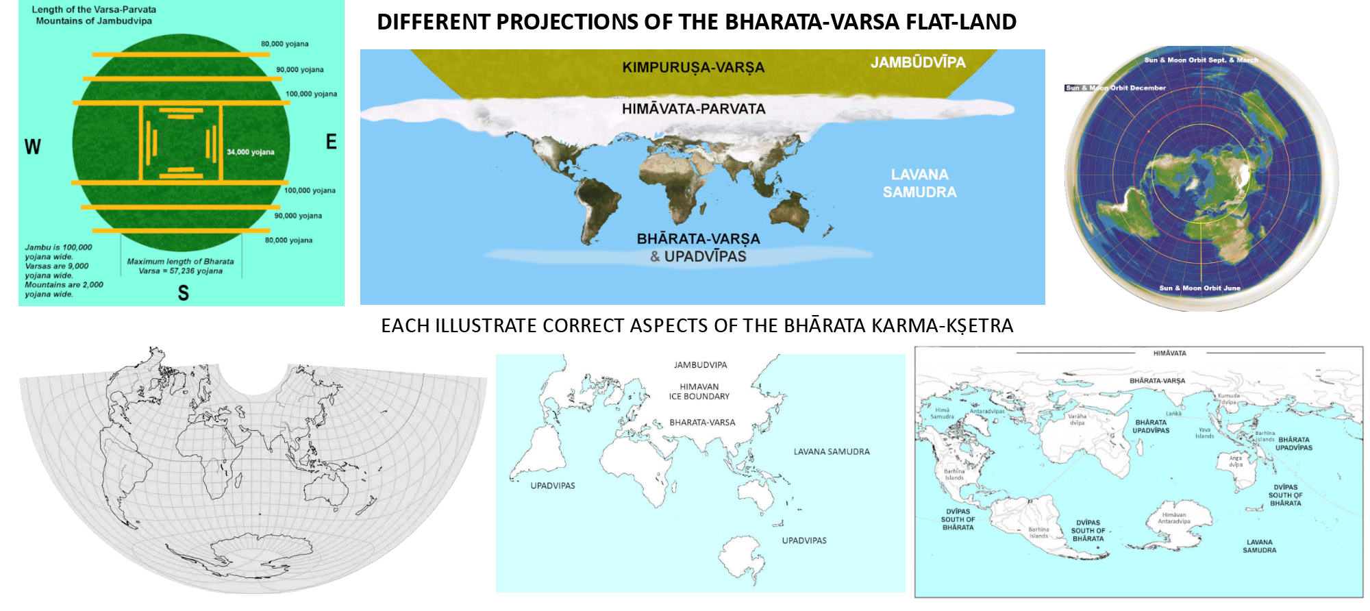
Six maps illustrating various aspects of how Bhārata-varṣa, as the Earth, projects onto the greater Earth plane of Jambūdvīpa
This new book “Puranic Geography of Bhārata-varṣa” will be of great interest to institutions teaching the History of Hinduism, the History of Geography, those studying comparative cosmology, Maps of Ancient Times, and the International Society For Krishna Consciousness, which is presently building an enormous Vedic Planetarium and Temple by the Ganges in Navadvipa, India.
3. The Ocean Dvīpas Associated with Bhārata-varṣa

Even hundreds of thousands of years before the Mahabhārata war, Indian ships that carried 1,000 men over the ocean are mentioned in the Ramayana and in the Rig Veda.
Bhāgavata Purāṇa 5.19.29-31:
Śrī Śukadeva Gosvāmī said: My dear King, in the opinion of some learned scholars, eight smaller islands surround Jambūdvīpa. When the sons of Mahārāja Sagara were searching all over the world for their lost horse, they dug up the earth, and in this way eight adjoining islands came into existence. The names of these islands are Svarṇaprastha, Candraśukla, Āvartana, Ramaṇaka, Mandara-hariṇa, Pāñcajanya, Siṁhala and Laṅkā. My dear King Parīkṣit, O best of the descendants of Bhārata Mahārāja, I have thus described to you, as I myself have been instructed, the island of Bhārata-varṣa and its adjoining islands. These are the islands that constitute Jambūdvīpa.
These are the last three verses describing Bhārata in the 5th Canto of Śrīmad Bhāgavatam, and while Śrīla Prabhupāda makes no comment on these verses, the previous Acaryas have said this:
Śrī Vaṁśīdhara:
Ashwanveshane means as they went in search of the sacrificial horse. The islands are mentioned by their names.
Śrī Bhagavatprasādācārya:
The ancillary islands to Jambūdvīpa are mentioned. They were not created by the chariot wheel of Priyavrata. They were created when Sagara’s children dug the earth in search of the sacrificial horse. The eight islands are individually named. They are eight as mentioned here. But in the Shakuntala Mahābhārata [Book 3, Vana Parva, v.134] thirteen islands are mentioned by number in the text and the commentator has given the names of three among the remaining five islands. He has said they are Romakapattana, Siddhapana and Yamakoti. He has not mentioned the other two names.
Śukadeva:
By saying “as they dug the earth,” the author conveys that Bhārata-khaṇḍa, though 9,000 yojanas broad, appears smaller, because of their digging.
Having now thoroughly discussed the identity of the Bhāratavarṣa as Bhārata-khaṇḍa or Kumārikā-khaṇḍa, the Indian Peninsular, and the pious capital territory of our entire Earth (called Bhāratavarṣa or Karma-bhūmi), we come to hear about the ancillary islands of Jambūdvīpa that are associated with India. After describing in great detail the nine khaṇḍas of the Indian mainland in the last chapter, we can now focus on the islands in the sea that actually are separated by ocean, reached by ocean ships or the mysterious Vedic air-ships.
Śrī Bhagavatprasādācārya makes the interesting comment about thirteen such islands in his notes. His list consists of the eight from this verse, including Laṅkā and Siṁhala, plus the four cardinal cities of Jambūdvīpa, mentioned by the translator, which originate from the Surya-Siddhanta: Yamakoti, Siddhapurī, Romaka and Laṅkā. This is a considerably speculative list on the part of the unnamed translator, as these additions are only cities, signified by the suffix puri and pattana. However, in the Mahābhārata verse itself, Lomasa-Suta does indeed mention “thirteen islands exist on earth” without listing them.
The actual list of thirteen islands, including the eight from the Bhāgavata Purāṇa, is very likely a variation of the lists in the Vāyu Purāṇa, plus those mentioned in the Mahābhārata and in the Ramayana. The thirteen islands could also be a reference to the 12 or 14 mountains that became islands in the ocean out of fear of Mahendra (Indra). The Vāyu describes at least nine islands that lie in the salt water ocean surrounding the Bhāratavarṣa peninsula. Fortunately, in the Vāyu these islands are described with some detail and can therefore be identified with some degree of certainty. This list of islands (excepting Laṅkā, Siṁhala and Yava) are not mentioned in the other Purāṇas, which mostly have the list of nine khaṇḍas starting with Indradvīpa. On the other hand, the Ramayana and Mahābhārata do furnish several characteristics about these ocean islands, which of course should never be confused with those gigantic sapta-dvīpas that have no connection whatsoever with the salt ocean of our experience.
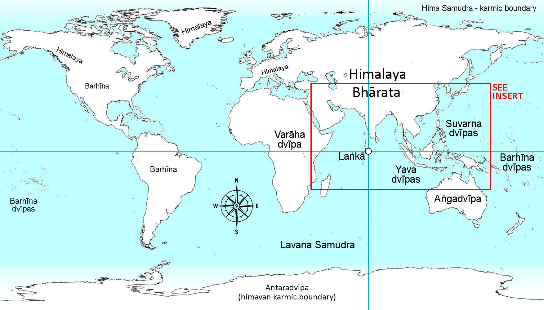
Purāṇic Map of the World – Bhāratavarṣa and the Upadvīpas – Islands and Continents of the Karma-kṣetra
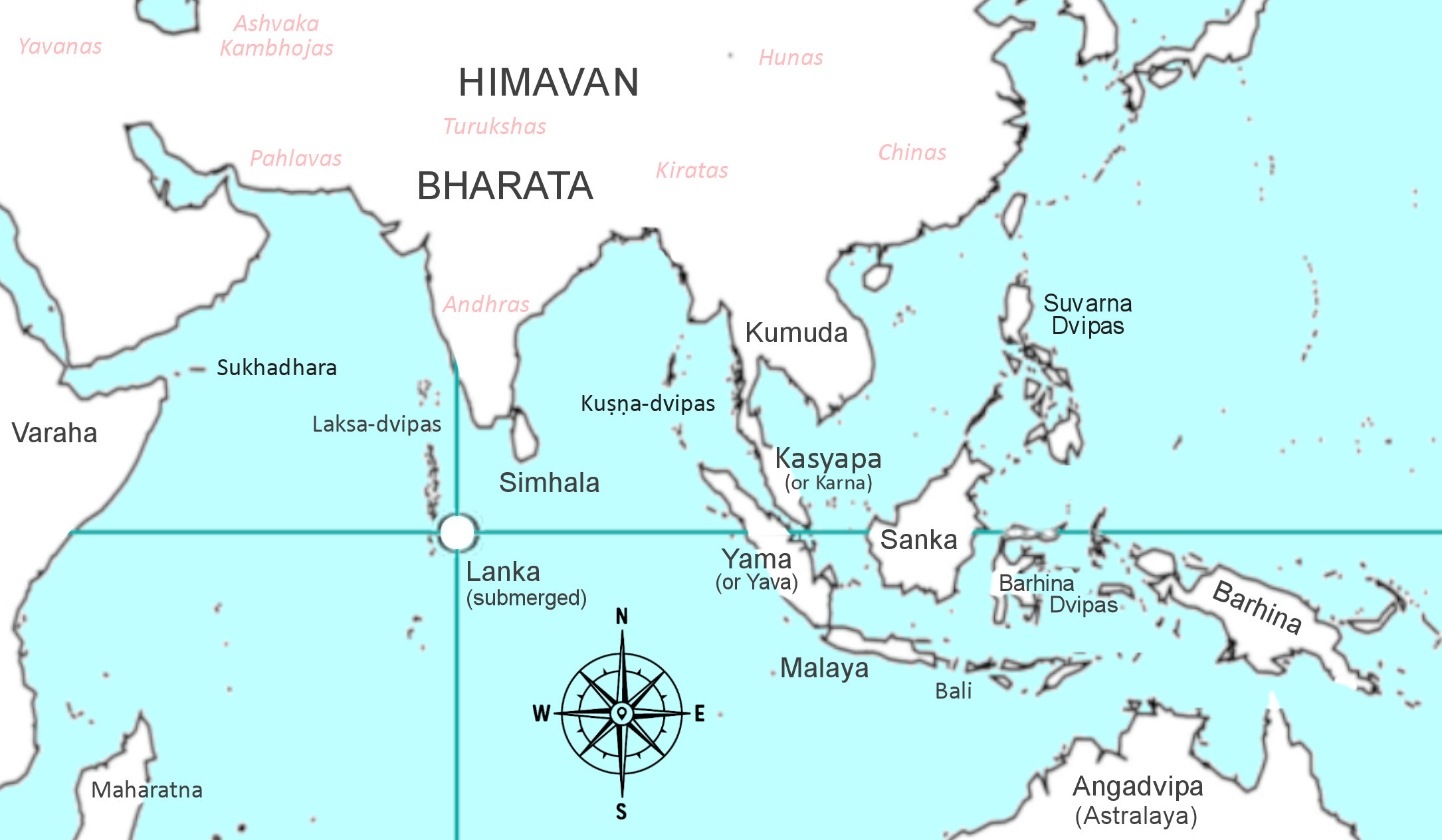
INSERT Purāṇic Map of South East Asia – Bhāratavarṣa and the Upadvīpas
The table provided at the end of this chapter, shown below, contains a compilation of all the oceanic islands and ocean provinces that have been mentioned and cross-referenced in the Bhāgavata, Vāyu & Varaha Purāṇas, the Mahābhārata & Ramayana, and the Siddhanta-śiromani. The Purāṇas call them the ‘upadvīpas’ or the ancillary islands to Jambūdvīpa, although most are within the jurisdiction of Karma-kṣetra – the southern ocean of Bhārata. Care has gone into excluding all references to the seven great concentric islands of Bhū-maṇḍala (Satpa-dvīpa), as well as the nine internal divisions or dvīpas (Nava-dvīpas) of the Bhārata mainland already discussed.
Many of the islands described here span the Indian Ocean, with references to those in the Pacific Ocean as well, while some which cannot be accessed by humans are heavenly islands much like the heavenly varṣas of Jambūdvīpa. Although much scriptural, historical, geological and geographical evidence has gone into the identification of these islands and continents as described in the third chapter of my Purāṇic Geography book, some associations remain as educated guesses.
| NAME OF DVĪPA | MODERN NAME |
| BHAGAVATA P. | |
| Svarṇaprastha | Java, Sumatra, Philippines (Suvarṇadvīpa) |
| Candraśukla | Heavenly island west of Uttarakuru |
| Ramaṇaka | Fiji (Kaliya’s isolated tropical island) |
| Āvartana | Antarctica (avartana = return away from) |
| Mandara-hariṇa | Madagascar (historical Harina) |
| Pāñcajanya | Borneo (conch-shaped with white mountains) |
| Siṅhala | Sri Lanka (Land of Sinhalese) |
| Laṅkā | Laccadive ocean ridge & Maldives (Treta yuga) |
| MAHABHARATA | |
| Nāga | Sumatra &/or Java (Rabbit-ear) |
| Kaśyapa or Karna | Malaysian Peninsular (Rabbit-ear) |
| Susa | Eurasia & Africa (Jack-Rabbit) |
| Peepal | North & South America (Fig-Trees) |
| vegetation dvīpas | Indonesia, Australia (Fruit & Vegetation) |
| RAMAYANA | |
| Yava | Java / Sumatra |
| Yava-dvīpas | Indonesia / Philippines |
| Varaha Mt. | Mt. Meru, Africa (“west of Arabian Sea”) |
| VARAHA P. | |
| Siṅhala | Ceylon (Sri Lanka) |
| Kataha | Kedah (Malaysian Peninsular) |
| Candradvīpa | White Isles of the Moon (west of Uttarakuru) |
| Bhadrākara | Golden Isles of the West (beyond Candradvīpa) |
| Suryadvīpa | Golden Isles of the Sun (north of Uttarakuru) |
| VAYU P. | |
| Vidyutvān Mt | African Eastern-Rift Ranges |
| Barhīna Islands | Papua, Pacific islands & the Americas |
| Aṅga | Australia |
| Yama | Sumatra (Suvarna or Yavadvīpa) |
| Nāgadeśa | Australia (Land of snakes) |
| Malaya | Java (Yava Islands) |
| Kañcanapāda Mt. | In Java (Mt. Semeru) |
| Śaṅkha | Borneo |
| Kumuda | Thailand & Cambodia (Land of Kumuda lotus) |
| Varāha | Africa (Nile River Aryans) |
| Laṅkā | Laccadive Ocean Ridge – Maldives |
| HISTORICAL | |
| Sukhadhara | Socotra |
| Maharatna-dvīpa | Madagascar (Harina) |
| Bali-dvīpa | Bali or Balāhaka |
| Rādhā-dvīpa | Rhodes (Greek Is. Rhodos) |
| Astra-laya | Austra-lia |
| Kuṣṇa-dvīpas | Andaman & Nicobar Is. |
| Barhīna-dvīpas | Sulawesi, Timor, Solomon Is, Fiji, Tahiti, etc. etc. |
| Barhīna-dvīpas | New Zealand, Nan Madol, Hawaii, Easter Is, etc. |
4. The “Hare and Fig-tree” Geography of the World
The following is an article published by Aravindan Neelakandan in Sep 21, 2017 from his online magazine < link. It discusses the ancient description of the Earth’s continents as resembling the shapes of an Indian jack-rabbit (susa), an Indian figtree (peepal) and various vegetations, surrounded by ocean. He points out how easily this analogy can be interpreted in many ways, and suggests that the brahmins and pandits of the 18th century reverse engineered the world maps of the day to match the ancient verses from the Mahabharata, with the intent of verifying their ancient knowledge in the face of British imperialism and bigotry:
~
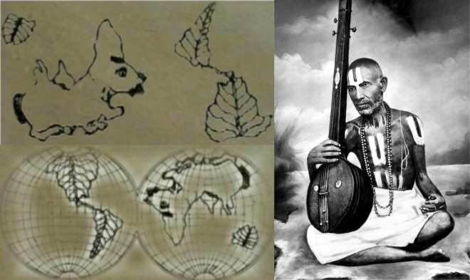
The Earth’s geography is described in the Mahābhārata, reported here, as looking like a rabbit and the sacred peepal tree leaves (ficus religiosa). Then, a claim is made. If the conventional modern world map is rotated 180 degrees, it looks amazingly similar to what the Mahābhārata has said about Earth’s shape as seen from space.

This story has been repeated in many other websites that propagate Hindu dharma and culture.
The same claim has been made by His Holiness Tridandi Chinna Śrīmannarayana Ramanuja Jeeyar. In a lecture from 2011 delivered at the Indian Institute of Technology (IIT) Madras, with a benign smile, Jeeyar asked the audience if they knew when the modern map of the world was made. He then asked his audience if they think a fairly accurate map of the world could have been made without help from the views from above – like from satellites. Then he pointed out that in the Mahābhārata it was said in one place that “the picture of the Earth was reflecting on the moon and there it looked like as if a rabbit is standing on its legs trying to catch hold of a big bush in front of it”. He then proceeded to show the rabbit and the big bush. When the rabbit, poised to jump on the bush, was morphed into the conventional map of the Earth, the audience broke into tremendous applause.
Vedic science stood vindicated in the hallowed hall of IIT Madras.
Now many Hindu websites have repeated this claim but after adding their spin to it. ‘First ever World Map was sketched out based on this Mahābhārata verse!’’ This ‘first world map’ is attributed to none other than Śrī Ramanuja, the great egalitarian Vaishnavaite seer who practiced Vedantic humanism.
Between that lecture and the claim on the website, we have two peepal leaves instead of a bush. So, then, what is the truth?
Let us first look at what the Mahābhārata verses actually say. The verses are from ‘Jamvu-khaṇḍa Nirmana Parva’, which in turn is within the Bhishma Parva book of the Mahābhārata. Here, Sanjaya explains to the blind king Dhritarashtra thus:
O son of Kuru’s race, I will, however, describe to thee the island called Sudarśana. This island, O king, is circular and of the form of a wheel. It is covered with rivers and other pieces of water and with mountains looking like masses of clouds, and with cities and many delightful provinces. It is also full of trees furnished with flowers and fruits, and with crops of diverse kinds and other wealth. And it is surrounded on all sides with the salt ocean. As a person can see his own face in a mirror, even so is the island called Sudarśana seen in the lunar disc. Two of its parts seem to be a peepul tree, while two others look like a large hare. It is surrounded on all sides with an assemblage of every kind of deciduous plants. Besides these portions, the rest is all water.
Kisari Mohan Ganguli, The Mahābhārata Of Krishna-Dvaipāyana Vyasa Translated Into English Prose(1883-1896)
As anyone who has read the passage can see, what the verses describe and what the purported morphing of the nineteenth-century world maps to that imagery suggests need a tremendous volume of the suspension of disbelief.
In the Indic tradition, the puranic geography is often pointed out to be the symbol of inner cartography. A good example is the work of Nilakantha Chaturdara of Maharashtra who lived in the second half of the seventeenth century. He collected manuscripts of the epic from different parts of India and brought out a comprehensive version of it. He also wrote a famous commentary on the Mahābhārata, which in itself was based on previous traditional commentaries. This was named ‘Bhārata-bhava-deepa’ (‘Light on the Inner Significance of the Bhārata’). In this commentary, he says these specific verses have an inner meaning – thus Sudarśana becomes the mind.
The flawed attempt to twist the Mahābhārata verses to fit the world map was undertaken in the nineteenth century by Śrīman Thiruvenkata Ramanuja Jeeyar (1806-1877)
The map in question was not drawn by Śrī Ramanuja (1017-1137). It was actually drawn by Śrīman Thiruvenkata Ramanuja Jeeyar (1806-1877). The first world map showing both the Americas and, fairly correctly, other continents had come into existence by the nineteenth century itself.
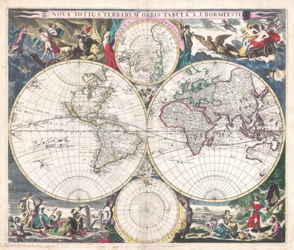
Hondius World Map published in Europe in 1630 CE
So by the time of Thiruvenkata Ramanuja Jeeyar, the Western maps showing Asian, European, African and American continents had arrived in India. All that the nineteenth-century Jeeyar did was, to take the Mahābhārata verses and do some ingenious, meticulous manual morphing of the map to fit the verse.
Interestingly, for Jeeyar, the rabbit was Europe and Asia, while for the twentieth-century Jeeyar, the rabbit was the two Americas – now that should make one wonder if it was belief-induced Rorschach of a very bad kind.
Yet this nineteenth-century attempt by Jeeyar is important only because it shows one way in which Hinduism faced the challenge thrown to it by modern science and missionary propaganda. It shows the way that should be avoided. At least Jeeyar was perceptive enough not to challenge the map but tried to integrate it into his scriptural knowledge.
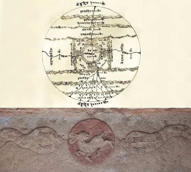
(Top) A depiction of Sudarsana island perhaps more faithful to the verses. (Below) Fifteenth-century Vijayanagar depiction of the rabbit-like reflection on the Moon. On both sides of the Moon are the serpents Rahu and Ketu, symbolic of the ascending node with the Moon moving to the north of the solar path and the descending node with the Moon moving to the south respectively
Though Christianity itself had a confrontation with the natural sciences because of its adamant literal and fundamentalist adherence to Biblical mythology, by eighteenth and nineteenth centuries, the missionaries had started using the knowledge generated by then modern cartography to challenge the Puranic geographical descriptions of both Hindus and Buddhists. While we need to do the necessary research for what transpired in such confrontations between Hindu scholars and missionaries, in the case of Buddhists we have some well-preserved documents of such debates.
For example, in 1873 in Śrī Lanka, a Wesleyan missionary, David da Silva, held up a globe during a debate with an audience of 5,000 people and asked Buddhist monk Gunananda to locate Mount Meru. If it was 80,000 yojanas high, 80,000 yojanas wide and 80,000 yojanas long and at the centre of the Earth, how was it that, asked the Christian preacher, it could not be seen by the humans? According to one report, an irritated Buddhist monk yelled from the audience, asking the reverend to climb on top of the tree of knowledge in the Garden of Eden and then he would be able to see Meru.
Interestingly, a Japanese scholar of the eighteenth century, Tominaga Nakamoto (1715-1746), who was perhaps the first scholar (whether Asian or European) to study Buddhism in a historical context, provided a Hindu-Buddhist interpretation to such cosmologies. In a passage that is relevant even today, the Buddhist scholar first acknowledged that such imagery had been borrowed from Vedic religion and went on to call those who wanted to find empirical “rights and wrongs of such things” as “small-minded people”. He cautioned against “people who have indulged in taking this up again when putting together theories about the universe” and said “it is extremely squalid, indeed ridiculous”. Then he concluded: “Teachings about the cosmos are in actuality quite vague and do no more than tell us of the inner workings of the mind. There is no way of knowing whether they are right or wrong. Hence I say that the cosmos arises on the pattern of people’s minds” (‘Emerging from Meditation’, 1735-1737).
Unfortunately in India, despite traditional commentators clearly providing the inner significance of such map-making in the language of Purāṇas and Itihasas, the emerging scholars tended to dismiss them. For example, Kisari Mohan Ganguli, who did a meticulous translation of the Mahābhārata into English (1883-1896), calls Nilakantha’s interpretation as “seeking to put sense in non-sense”. Naturally, one can understand the socio-cultural context in which Thiruvenkata Ramanuja Jeeyar was trying to invent in the verses of the Mahābhārata the world map of his century. However, the development of inner sciences and a deeper understanding of world mythologies have shown that the Indic tradition of cosmologies and puranic sacred geographies were created consciously to serve a deeper purpose. Even Western Indologists are beginning to acknowledge this aspect. Dr Ariel Glucklich points this aspect out:
The narrator (suta) of this vast cosmography was both a realist and a rationalist. He prefaced his geography lesson with a reminder to his audience that the true divisions (dvīpa) of the world added up, in fact, to thousands, and that both his seven- and four-part schemes were only simplifications. Only reason, he added, should be used to explain immensities or realities that extended beyond common experience. His maps, in short, were representations of something greater—mere facsimiles, however reasonable. He seemed to be urging restraint among his listeners when they considered comparing what they heard in his narration to what was truly out there in the world.
‘The Strides Of Viṣṇu’ (Oxford University Press, 2008)
Dr Glucklich says it “is still good advice for modern readers of the Purāṇas”. As ever, however, it was the great seer-poet Śrī Aurobindo who provides (as early as 1920) a holistic way of looking at Puranic cosmology while warning about the pitfalls. The passage below from Śrī Aurobindo’s Foundations of Indian Culture, though a bit long, provides the key to understanding the ‘fantastic geography’ of Puranic and Itihasic lore:
The so-called fantastic geography of the Purāṇas, as we are expressly told in the Purāṇas themselves, are a rich poetic figure, a symbolic geography of the inner psychical universe. The cosmogony expressed sometimes in terms proper to the physical universe has, as in the Veda, a spiritual, and psychological meaning and basis. It is easy to see how in the increasing ignorance of later times the more technical parts of the Puranic symbology inevitably lent themselves to much superstition and to crude physical ideas about spiritual and psychic things. But that danger attends all attempts to bring them to the comprehension of the mass of men and this disadvantage should not blind us to the enormous effect produced in training the mass mind to respond to a psycho-religious and psycho-spiritual appeal that prepares a capacity for higher things. That effect endures even though the Puranic system may have to be superseded by a finer appeal and the awakening to more directly subtle significances, and if such a supersession becomes possible, it will itself be due very largely to the work done by the Purāṇas.
Śrī Aurobindo, The Foundations Of Indian Culture (First Edition: 1953)
So we have on the one hand the traditional and yet scientifically sound way of approaching the poetic language of ancient Indic literature. We can understand what psychological and spiritual dynamics were at work in creating these cosmologies and sacred geographies. To proceed through this path, one needs an in-depth study of our tradition as well as of modern sciences, particularly psychology. It is to walk in the path of Patanjali, Thirumular, Nilakantha and Śrī Aurobindo.
It requires from the seeker hard work, lifelong perseverance and intelligence of high quality. To make it a discipline, we also need to build institutions. On the other hand, we can do a demonstrably wrong, laughable Zakir Naik-type of science-religion mapping to humour our petty egos and, in the process, become a laughing stock of any intelligent mind that seeks truth. And Zakir Naik is a terrible tragedy that can befall any religion.
~
In my book “Puranic Geography of Bharata-varsa” the original sanskrit verses found in several Puranas and the Mahabharata which describe the world as Sudarśana-dvīpa are analysed to uncover the truth about this description, and I discuss ways to use this information to identify the Earth’s continents and islands by their ancient Sanskrit names.
TO BE CONTINUED – last updated 11th July 2020
(Summary of Chapters 5,6 & 7 pending)
PLEASE FOLLOW THIS LINK TO READ MORE ABOUT THE PURANIC EARTH
Please note that due to the new YouTube “Fact-Check” Policy, Videos about “Flat Earth” are being taken down, banned, ‘fact-checked’ by YouTube owned subsidiary groups which have decided to call “Flat Earth” research fake news or have placed them in particular age categories to restrict the genuine enquirer, who is now insulated and cut off from any real research. It is for this reason that some videos I suggested to watch over the last 4 years have been removed or restricted from viewing. Everyone seems to have a price, and it looks like YouTube have now reached that threshold. Take care, and watch my latest videos about Puranic Geography before they are deemed to be “Fake Research” too! Your well-wisher, Soolaba.
UPDATE!
Please enjoy this latest scientific release (2 May 2021) by FECORE, that shows the ‘standard curvature formula for the Earth’ has been disproved by scientific experiment and observation:
Copyright © 2018-2022 Steve M. Doyle (Soolaba)


I congratulate you is a very good investigation. I have read the fifth song of the Bhagavatam which is very interesting, but I always had doubts about how the continents were organized, it is said that we are in bharata varsa south of jambuduipa but it was not clear if the continents were stuck to jambuduipa or not . so thank you very much for the quotes of the other puranas that clarify so much. I have a question if the airplanes go around the continents then how would this happen in the pure map that is a planisphere? In the map of the terraplanistas the planes turn around the flat circle, but in this new model it is difficult to understand how this would happen. Thank you, I’m looking forward for your answer.
Bharata-varsa, our Earth, has a karmic boundary, which in some ways, acts like a sphere. Srila Prabhupada said that we are trapped on this one lotus petal of Jambudvipa, and by traveling east or west we are forced to return. I use the example of a closed lotus flower at night. Our world is like that. Bharata-varsa is like that. We are like the bee trapped inside during the night. The jiva-soul can’t escape simply by sailing or flying. Even though the measurements of the Earth resemble the measurements of a sphere, the Earth, Bharata, is definitely flat and immobile. Nobody can photograph the curvature of the Earth. Photos from space are compilations of images. This is the ‘achintya’ or inconceivable aspect of our world. The Puranas explain this phenomena in terms of the creation pastimes of higher dimensional beings: Bhumidevi – Earth, Suryadeva – the Sun, Chandradeva – the Moon, while the atheistic scientist can perhaps imagine a 4th physical dimension to explain the disparity between puranic descriptions, and the reality we see as conditioned souls.
Hello again Hari bol. Thank you very much for your answer, I am a devotee of Krishna and I constantly read the Bhagavatam, I know that bharata varsa is the earth because of the measures that the bhagavatam shows. some think that bharata varsa is India but they have not compared the measures 72,000 miles could never be the Indian this measure is too big for India, but it would make more sense as a measure of the land. of course a flat earth. there is a description of some islands south of jambuduipa are 9 in total, you explain that these islands would be the continents we know, I would like to know the exact location of those continents, since I do not trust the maps that we have been taught since children, and the alleged photos of NASA are a lie, so the location and shape of the continents is something that should only be in the vedas. the cartographers like mercator I do not know if they located the continents well? I have an additional question the islands that describe the bhagavatam south of jambuduipa are 9, but the continents that we have been taught are not as many as to be those islands, the known continents are America, Europe, North Pole, Asia, Africa, Australia and Antarctica, which would give a total of 7 continents but not 9, are there more continents? what about the plane’s trip around a center (north pole) on a flat land, how could it be given on a Vedic map if it seems that the continents are very close to jambuduipa as samples on one of your graphs, then the plane could not give this circle around the north pole? Thanks for answering my concerns.
Juan Carlos pardo, thank you for your enquiries. In the future, it is easier for me if you number each question.
1. You say Bharata varsa is 72,000 miles and too large to be India. There are several problems with your understanding of this. A) In all 18 puranas the land of Bharata is defined by the arrangement of seven prominent mountain ranges and the very famous rivers that flow from them. This sloka is there in all puranas: “Pariyatra, Riksha, Vindhya, Suktimat, Mahendra, Malaya and Sahya are the 7 kula-parvatas of Bharata-varsa”. If you study the geographical map of India today, these 7 ranges, and the rivers that flow from them are all in the subcontinent of India. This is both visible and shastric proof that Bharata in one very real sense is ancient India. B) In the same set of slokas it is stated that the distance from cape Kanyakumari to Gangotri is 1,000 yojanas. You will see on today’s map this is a distance of 1,587 miles. Using this ratio, the distance from the North Pole to the South Pole is approx 7,900 yojanas, which is very similar to the Bhagavatam sloka’s N-S length of 9,000 yojanas. We can now understand that the whole Earth is called Bharata-varasa after the famous capital territory of India, also called Punya-Bhumi.
2. Regarding the upadvipas, or ancillary islands mentioned in the Bhagavatam, eight are clearly listed, not nine. They are named Svarnaprastha, …… Sinhala & Lanka. We know the last two are islands south of India, the present day “Sri Lanka” is Sinhala, and the submerged range visible as the Maldives is what remains of Ravana’s Lanka. This is supported by the mathematics of the Surya-Siddhanya and other puranas. In the other prominent puranas other names are given for the upadvipas, such as Barhina-dvipa, Anga-dvipa, Malaya-dvipa, Lanka, and so on. Because there are accurate descriptions of the natives, the mineral resources, the vegetation, the size and shape of these islands, they can be identified with the continents of today’s world. The Vayu Purana says there are 1,000s of islands, but only a small number are as large as North and South America, Africa and Australia.
3. Mapping the world as a flat image has always been a problem for cartographers. This is an issue misunderstood by 99% of flat-earth supporters. This is the “achintya” aspect of the world that Sri Vyasa, Sri Suka and Sri Suta all warn us about. The mathematics of the world is spherical in nature, while the world – including Bharata and Jambudvipa – are indeed large realms of flat land and flat seas. That the supposed curvature of the Earth can be photographed has continually failed, along with any evidence that the Earth is spinning at about 1,000 miles per hour! This is all modern scientific speculation not supported by the scriptures.
4. If someone traveled over the north pole, due to the stringent laws of karma, and the illusory power of Mayadevi, they would find themselves going south again. However, if someone had the karmic qualification, he could pass beyond the ice and reach Kimpurusa-varsa, as the puranic maps indicate. It is also possible by mystic qualification that someone can enter Kimpurusa-varsa and Jambudvipa through the Indian portion of the gigantic and mostly hidden Himalaya mountains.
I hope these four points help answer your questions.
[…] Purānic Geography […]
Thanks a lot for your deep research with Purana references.
1)I am unable to visualize dweeps n oceans. How do can we correlate it with current physical earth?
2) What about length n height of those dweeps and oceans?
3) When do rest all 7 dweeps n ocean? Last one in series is puskar dweep n swachhodak ocean.
4) Also there are described sea of sura, ikshu,dahi, milk,etc?
5) How to recognize length, with n height? Is there any model picture which shows with side view and top view to able to visualize it?
6) I have read in one of the blog about the Bhigola Sangrah book. Would you be able to look for that book. It is in sanskrit by raghvedndra swamiji.(Source: (a) https://www.srsmatha.org/publications.php) but unable to get it I think it is not available but i assume it has some more reference could be useful in further researches… in addition there are few discussion with references :
(b) https://chiraan.com/2010/07/31/bhuvankosha-varnanam/
(c) https://chiraan.com/2012/03/31/bhuvan-vinyaas/comment-page-2/
Hope will get your response
My book of Puranic Geography is titled “of Bharata-varsa”. The scope of of my book is directed at the Bharata-varsa portion of Jambudvipa, and its southern salt ocean. It does not discuss the sapta-dvipa islands, nor the oceans of fabulous substances. Nor does this book deal with the movement of the sun, moon, eclipses and stars, but only discusses the geography of our known world in Puranic terms, which is generally equated with Bharata-varsa. The capital territory of Bharata-varsa is often called Bharata-varsa also, along with the names Bharata-khanda and Kumari-dvipa.
The book offers some simple explanations of the perception of stars and galaxies in terms of a hyper-dimentional tree of manifestation within a limited billion billion mile universe with one Sun and a central Meru, near where Earth resides on the southern petal. The Sankhya vedic science explains the subjective personal perception of the Suns path overhead Bharata-varsa, while it actually travels thousands of miles horizontally away from Meru orbiting Manasottara Mountain.
Srila Bhaktivedanta Swami describes that the actual height of the Himalya, also the next varsa of Kimpurusa, also Meru, the Sapta-dvipas, their wonderful oceans, and the Lokaloka Mountain boubdary of the universe, all beyond the limit of man’s perception. Just as Arjuna could not see the realm of Uttarakuru in Mahabharata, we cannot see beyond the enclosure of Karma-bhumi – the Earth Plane(t). Science also supports the perceptible vanishing point of vision of eyes and cameras, alowing the sun to set on a flat plane, and a ship to be seen to rise above predicted ocean curvatiure by a zoom lense, and to see south ‘hemisphere’ stars rotate backwards. The fact that 4-Dimentional objects cannot be fully seen or understood by 3-Dimensional beings, also lends to the invisibility concept of Bhagavatam Sapta-dvipas and fantastic oceans. Lastly, the concepts of Achintya-shakti and Maya-shakti also hamper our ability to see the universe as it is in the Bhagavata Purana.
I have not found the book of Raghvedndra Swami that you have mentioned.
Hare Krishna prabhu. Fascinating research, very interesting. Looking forward to read your book.
1. You wrote that the vanishing point explains how the “south ‘hemisphere’ stars rotate backwards”. Can you explain how?
2. You also wrote “The Sankhya vedic science explains the subjective personal perception of the Suns path overhead Bharata-varsa, while it actually travels thousands of miles horizontally away from Meru orbiting Manasottara Mountain.”
This is a question I’ve been thinking about many times; how it is that we experience the sun to be above our heads while it’s actually orbiting manasottara mountain far away. Ok, one answer is the Lord’s acintya shakti, but now you say that sankhya explains this. Can you give some further explanation or redirect me to some other source where I can read about it? This question has been nagging me for some time…
Thank you
1. There is some vedic reference to how the Asuras see the ‘southern hemisphere’ rotate in the opposite direction to the Suras in the ‘Northern Hemisphere’ even though Bharata-varsa is flat. This curiosity is explained in the Siddhanta-Siromani in the chapter which explains that the ‘spherical’ mathematics of Earth is required for complete mastery of astronomy and astrology – because the sky is viewed from the conditioned Bharata-varsa vantage point. However, more to the point, there are many Flat Earth and Vedic Youtube videos which attempt a logical explanation of this phenomenon on a flat Earth plane, for example:
FLAT EARTH – SOUTHERN STARS ROTATION EXPLAINED, Why Sun sets at South West?
How the Southern Stars Work on Flat Earth
YOUTUBE: Mysterious Orbits – Sadaputa Dasa
YOUTUBE: 4D Toys: a box of four-dimensional toys, and how objects bounce and roll in 4D
2. Sankhya Vedic Physics includes consciousness, physical laws and metaphysical laws, while modern cosmology does not. This affects how humans interpret what they see in the sky – for example, seeing the Earth as flat but seeing the sky as a dome, or, seeing the sun overhead while it is many yojanas away over Manasottara Mountain. What the Bhagavatam and the Sages see are the invisible connections between the layers of universal creation manifest by Lord Brahma, while the conditioned jivas, in all three realms, see the sun subjectively, not objectively. According to our conditioning, we see the sun overhead, while actually His path is over Mansottara Mountain. Sanhkya will give a different measurement between celestial bodies as it measures the invisible ropes of prana that connect them, like branches, while the human eye will see a different celestial situation because he sees only the gross layer of manifestation – like only measuring the leaves on the tree, and not measuring the unseen branches.
Hari bol !
Thanks for your response. and sorry to revert back too late after your response. but after seeing your post and conversation on FB page Today it strike me to visit this page.
I have tried to search of your book “Bharata-varsa”, but i was unfortunate enough to locate it.
Kindly share with the cover (index page) and source.
i am not able to recognize the sun movement. On the following link i have observed and track with my known location from India and it looks like that sun is not so big as define. How can I reach to that conclusion that from above site, I have been taking two nearest cities data available with distance and its direction from sun also shows in kilometer ranges. What i felt that in Purana’s the size of the sun is indicating the total light spread-ed area, that might be the concept and with that consideration it might be shown bigger. otherwise sun appearing from those city(zenith) sun is just like a torch light beam.
Also in below link you can find the sun relative speed is in the ranges of 1540 KMPH. sun travels speed is @ 26 KMPH and from any point of time you can observed that sun can crsoo that point in two minutes time means cold be smaller sinze(beam).
Refer under the ” Sun-Moon”-> day and night map.
https://www.timeanddate.com/worldclock/sunearth.html
Hari Bol.
The Earth planet looks like a sphere in this depiction that was authorized by Srila Prabhupada: https://back2godhead.com/wp-content/uploads/2012/12/118_1976_11-11-37.jpg
Here is the definitive commentary by Visvanatha Cakravarti Thakura where he explains the dimensions of Bhu-mandala and exactly what Varaha lifted. The facts are clear:
Learned scholars who are free from mistakes, illusions and propensities to cheat have thus described the planetary systems and their particular symptoms, measurements and locations. With great deliberation, they have established the truth that the distance between Sumeru and the mountain known as Lokāloka is one fourth of the diameter of the universe — or, in other words, 125,000,000 yojanas [1 billion miles]. SB, 5.20.38
From Visvanatha Cakravarti Thakura’s commentary:
Bhūloka is 493,400,000 yojanas (3.947 billion miles) with the oceans, islands and mountains. There is thus a space of 1,700,000 yojanas from the universal shell all around. Because of this Śeṣa holds up the earth and the elephants of the directions steady it.
To explain the dimensions in any other way would make the descriptions mentioned here useless, since it has been mentioned that the diameter to the shell of the universe is 500,000,000 yojanas.
It would also be impossible for Varaha to lift up the earth (bhū-maṇḍala) which has sunk in the Garbodhaka Ocean during Cākṣuṣa Manvantara, if bhu-maṇḍala was 500,000,000 yojanas in diameter.
Prabhu reverences. This is the best page to learn from Vedic cosmology. I have a query, I have seen several paintings where the turtle is seen in Kurma holding the universe from the bottom. In video vedic cosmos 3 you can see Kurma in the ocean Garbhodaka and on it is Ananta sesa holding the bottom of the universe. I would like to know some quotation from the Vedas in which Kurma is mentioned in the Garbhodaka ocean. Thank you very much.
Padma108, thank you for this curious question. Unfortunately, although I have access to all 18 Mahapuranas, they are not all in a searchable format. Research would be so much easier if I didn’t have to rely on the ‘contents’ page of the pdf. I have looked for references to Lord Kurma holding up either the subterranean elephants or Lord Anantadeva. I only found one sloka, from the Sri Brahma-vaivarta Purana (Chapter 6 verse 211, Sri Radha-Krsna-samvada. A Conversation of Sri Radha and Sri Krsna):
“For the earth, the resting place is Lord Sesa. For Lord Sesa the resting place is the great tortoise beneath Him. For the tortoise, the resting place is the wind. For the wind, the resting place is I Myself”
Here are definitive slokas from the Skanda Purana 2.1.36.20-26 about the four elephants holding up the Earth along with Ananta-sesa upon the back of Kurma-avatar ……
20-26. After lifting up the Earth from beneath the nether worlds thus the Lord placed her firmly in the midst of the waters of the Ocean. When the Earth was lifted up by him, the water that filled up the space between the Earth and the atmosphere became the immovable line of demarcation of the boundary made by him. After establishing the Earth thus he placed the Elephants of the Quarters, the King of Serpents (Ananta-Sesa) and the Tortoise (Kūrma) for giving her extra support. That receptacle of mercy (Hari) willingly applied his own Sakti (power) in an unmanifest form as a support for them all. As Hari thus stood in the form of Boar after retrieving the Earth, the residents of Janaloka beginning with Sanaka eulogized him. After propitiating Purusottama in the form of Boar and at his behest, Brahma created the universe as before.
Also take note that in the Ramayana, when the story of King Sagara is retold, his sons digging the Earth meet four gigantic elephants holding up the Earth in the four directions:
On catching up the words of their father, the great-souled Sagara, his sixty thousand sons rushed towards the surface of the Rasatala, the netherworld. (1 40 12) “While digging the earth there they beheld a mountain similar easterly Elephant named Virupaksha, which is bearing the eastern side of earth s surface on its head. (1 40 13) “Oh, Rama, the legatee of Raghu, that great easterly Elephant Virupaksha is bearing the entire eastern earth along with its mountains and forests on its head. (1 40 14)
“On certain occasions, oh, Rama of Kakutstha, when that great Elephant moves its head desiring respite in tiresomeness then earthquakes will occur on earth. (1 40 15) “They circumambulated the great Elephant in supplication, oh Rama, and on worshipping that Elephant which is the protector of the easterly direction they proceeded to netherworld duly splitting the earth. (1 40 16) “After splitting the eastern direction then they split opened the southern direction, and even in southern direction they beheld an Elephant that is similar to a very great mountain, and that is sustaining southerly side of earth on its head, and on seeing that mammoth Elephant of venerable character, namely Mahapadma, they went into an inordinate astonishment. (1 40 17, 18)
“On circumambulating that Elephant Mahaapada in supplication, they the sixty thousand sons of great-souled Sagara scooped out the westerly direction. (1 40 19) “Even in the westerly direction, those great mighty sons of Sagara beheld an infinite and mountain similar Elephant of western direction, called Sumanasa. (1 40 20) “Circumambulating that Elephant namely Sumanasa on the western side, and even on asking about its well being, then they reached the northern direction duly digging the earth. (1 40 21) “In the northern direction, oh, Rama, they beheld Bhadra, a snow-white Elephant with an auspicious body bearing the northern side of this earth. (1 40 22)
“On touching that Elephant reverently and also circumambulating it, those sixty thousand sons of Sagara further burrowed to the surface of the earth. (1 40 23) “The sons of Sagara have then gone to the auspicious northeast direction, Ishaana Digbhaaga, Shivasthaana, and all those sons of Sagara have tunneled the earth rancorously. (1 40 24) “But all those great souled and great mighty ones with terrible dash have seen the Infinite Vasudeva in the form of sage Kapila there in the northeast, and oh, descendant of Raghu, they have also seen the ritual Horse moving nearby that sage Kapila, thus all of the sons of Sagara obtained a matchless delight. (1 40 25, 26)
Haribol Dilip, also excuse this late response. My book “The Puranic Geography of Bharata-varsa” has not yet been published, as word for word Sanskrit translations are still required. However, a summary draft of the book is available for download here ….
Click to access puranic-geography.pdf
Regarding the visible movement of the sun, a whole year of observations was made by FECORE scientists around the world studying the flat-Earth globe-Earth debate. Their conclusions were that no flat map of the world was capable of explaining all solar observations, yet simultaneously, neither was there seen any scientific proof of global curvature.
The Sankya Vedic physics explains that by the measurement of the Earth and of the flight path of airlines etc., we obtain a MENTAL or mathematical model of Earth as a sphere. However, by simple telescopic observation, no spherical curvature can be found. This has also been stated in the Siddhanta-Siromani. Therefore the PHYSICAL model of the Earth is observed to be flat. Sankhya explains that the Mental and the Physical planes are different levels of manifestation, and are thus inconceivably the same but different, or ‘achintya’ in Sanskrit. The Puranas explain the light of the sun/Surya is SUBJECTIVE to jivas in each loka, and He projects light like a torch over the plane of Bhumandala. Suryadeva Himself is Paramatma, and He controls the sight of every conditioned jiva.
Please listen to the entire discussion about the Flat Earth Disc, Dome Sky and Torroidal Lens of observation in this video ….
Regards, Soolaba.
Thanks a lot once again.
I tried to see the video link, but there in nothing there. It appears to me as three dots in the post here above and on the blog page I do not find your response.
So kindly share the video link please again.
With Regards,
Dilip, sorry the YouTube link did not work. Alternately, search Youtube for this title: “Chris Monk Sellye, Mike Cavanaugh, Steve Torrence [GLOBEBUSTERS]”. The URL link you can copy and paste is … https://youtu.be/FhYwg7IF27M
FECORE is a group of scientists who recognize the Earth has no curvature. They are therefore trying several maps to illustrate the flat earth and the observable path of Sun and Moon with the standard azimuthal FE Map and the possibility of a magnetic toroidal lens acting on the ‘Earth Disc’. At the end (2 hours 40 minutes in) they summarize their conclusions. Perhaps that video is blocked in your country, in which case use a VPN to see it.
With Regards, Soolaba.
i really need because i believer the earth is geocentric.Thanks a lot….
Respected Sir, Where i can read your precious book for free as I belong to lower income family, and suffering from White matter disease, affordability is an exclusion for me for time being. kindly mail me your precious collection or tell me the price that i will have to pay to read your book.
Thanks
Brij Mohan
Respected Brij Mohan, my eBook publication of “The Puranic Geography of Bharata-varsa” has been postponed due to lack of interested Sanskrit translators. I could simply publish the eBook today, but it would be without accurate translation of key slokas from the Puranas, and would therefore not pass my academic research standard. To date, many verses come from unreliable English volumes translated by foreigners who do not follow the regulations of Sanatan Dharma, consider such texts as mythology, or give very poor English translations by not understanding the seemingly fantastic cosmology chapters that describe Jambudvipa. My own skill at translating Sanskrit is still very limited.
However, in the second paragraph below the long list of Puranas to download, there is a link to more sections of my book that have been published on another site. Please follow the link that says: preview of the book “here”.
If any translators are interested in helping me finish my publication, could they please contact me through the comments option, or directly by email: soolaba[at]yahoo.com (NOTE: [at] has been posted here to prevent email-bot adware, just replace with @ ).
A question has come in regard to my illustration of The Bhagavata Purana map of Jambudvipa. As this question and answer are not clearly visible, I will reproduce them down here, with the page comments.
Before I go into details about yojanas and divisions of Bharata, it seems so many students of the Srimad Bhagavatam have not compared the Bhu-mandala cosmologies described within the other great Puranas. One extremely neglected point is that the cosmologies written in different Puranas often refer to different kalpas or days of creation. This is easily determined by the different family trees, or genealogies, that lead to the division of Bharata-varsa. For example, in this Varaha Kalpa, within this Vaivasvata Manu, at the beginning of the 28th Kali Yuga, Sri Caitanya has appeared. Krishnadasa Kaviraja has stated in his Caritamrita that representatives from all nine khandas came disguised and offered prayers to the Lord at this time. The same nine khandas were ruled in previous kalpas by different descendants of Manu. In the Kalpa of the Skanda Purana, Priyavrata was grandson of Brahma, Nabhi was his grandson, Bharata his grandson, and nine of his grandchildren including Indradvīpa, Kaśeru, Tāmradvīpa, Kumārikā and others divided up the Bharata-varsa. In another kalpa, it was not the grandchildren that divided Bharata into nine, it was his own children, Indradvīpa, Kaśeru, Tāmradvīpa, Kumārikā and other. In the kalpa of the Bhagavatam, Bharata’s brothers ruled the nine khandas, and Bharata divided the Bharata-varsa into five regions headed by his son Sumati. In the Śveta kalpa when the Vayu Purana was composed, King Bharata inherited the kingdom from his father Ṛṣabha, but was already divided into nine khandas. In the 12 Puranas that list the nine khandas of Bharata, they have resulted from 8 different family trees, each from a different kalpa. Sometimes Bharata-varsa is divided into five regions, and sometimes seven regions.
The factor of kalpa-bheda should always be remembered when studying Bharata geography from different Puranas!
Krishna Dharma das has commented and asked:
“Plainly the earth is not 9000 yojanas in size, more like 1000 is the diameter. How do you make sense of this? There is mention in some Puranas that there are nine divisions of Bharata and we reside on just one, called variously as Sudarshan, Gandharva, Navadvipa or just Bharata. Any thoughts?”
Krishna Dharma, there are many slokas in the Puranas that give different values to the yojana. There are a dozen slokas that state the distance between Gangotri and Cape Kanyakumari, amongst other identifiable landmarks, are 1,000 yojanas apart. Today this equates to about 1.5 miles per yojana or 8,300 yojanas from Earth’s northern limit to its southern limit. Secondly, Srila Bhaktisiddhanta Sarasvati states the yojana is approx. 5 miles for astronomical purposes, which agrees with the measure provided in the 54th chapter of the Narada Purana. Thirdly, it is stated in several Puranas that the length of the yojana is relative to the height of man and the size of a cow, both of which gradually decrease in size within Bharata-varsa as a result of the decline in yugas. Fourthly, there are statements in every Purana before the measurements of Jambudvipa are given, that the mathematics of Bhu-mandala and its mountains are inconceivable (achintya) and simply guesswork when calculated by conditioned souls. To theorize that the yojana remains at 8 miles within the boundary of Bharata-varsa is not supported by shastra.
Regarding the nine divisions of Bharata-varsa, their creation and their individual kingdoms are discussed in detail in the Skanda Purana, where the size and location of Indradvipa-khanda and Kumarika-khanda are identified without doubt. From this evidence, and from that in the Markandeya Purana, the Brahmanda Purana, the Mahabharata, and the Brihat-Samhita, there is no indication that Earth is only one khanda of Bharata-varsa, as popularised by Danavir Goswami and other contemporary Vedic cosmologists.
The term ‘navadvipa’ comes from Srila Visvanatha Cakravati’s commentary on the Vishnu and Bhagavata Puranas. He clearly indicates the Indian Peninsular is the ‘navadvipa’, which is surrounded by the other khandas. He places the Kiratas (Indo-Chinese) on the eastern border, the Assamese (Kamarupa) within the eastern part, Magadha (South Bihar) and Odhas (Odisha) and Kalinga (extending to Andhra Pradesh) in the southern part, and the Yavanas (Turks and Greeks) on the western boundary of this 1,000 north-south yojana ‘Navadvipa’ or ‘Bharata-khanda’. There is no possible misidentification that this khanda he is describing is the Indian subcontinent.
The term “Sudarsanadvipa” is found only in the Mahabharata. Danavir Goswami has done a great job of twisting his translation to fit his own model. There is no mention of a sphere bael-fruit in the Sanskrit. In the Sanskrit, Sudarsanadvipa contains all NINE VARSAS OF JAMBUDVIPA and is therefore circular [parimaṇḍalo] like a wheel [cakrasaṃsthitaḥ], surrounded on all sides [samantāt] by the ocean [samudreṇa]. There is no mention of a “Wheel of Time” or a “Kala-Cakra” in the Sanskrit ie; no mention of ‘kala’ or ‘vela’ (time). In the Sanskrit there is no mention of the peepal-shaped leaves, only the figtree. The Sanskrit says two parts resemble an Indian hare, and two parts resemble a peepal (Indian figtree). The Sanskrit says (06,006.016a) “two parts figtree in that place two parts hare large”.
06,006.012a sudarśanaṃ pravakṣyāmi dvīpaṃ te kurunandana
06,006.012c parimaṇḍalo mahārāja dvīpo ‘sau cakrasaṃsthitaḥ
06,006.014c lāvaṇena samudreṇa samantāt parivāritaḥ
06,006.015a yathā ca puruṣaḥ paśyed ādarśe mukham ātmanaḥ
06,006.015c evaṃ sudarśanadvīpo dṛśyate candramaṇḍale
06,006.016a dvir aṃśe pippalas tatra dvir aṃśe ca śaśo mahān
06,006.016c sarvauṣadhisamāvāpaiḥ sarvataḥ paribṛṃhitaḥ
06,006.016e āpas tato ‘nyā vijñeyā eṣa saṃkṣepa ucyate
06,006.016f*0022_01 tato ‘nya ucyate cāyam enaṃ saṃkṣepataḥ śṛṇu
Nowhere in the Sanskrit is Bharata equated with Sudarsanadvipa, look where the word Bhārata is used within the list of varṣas of Kiṃpuruṣā, Harivarṣa, Bhadrāśva, Ketumāla, & Kuru.
06,007.006a idaṃ tu bhārataṃ varṣaṃ tato haimavataṃ param
06,007.006b*0026_01 tataḥ kiṃpuruṣāvāsaṃ varṣaṃ himavataḥ param
06,007.006c hemakūṭāt paraṃ caiva harivarṣaṃ pracakṣate
06,007.011c bhadrāśvaḥ ketumālaś ca jambūdvīpaś ca bhārata
06,007.011d*0028_01 ketumālaś caturthaś ca meroḥ paścimataḥ sthitaḥ
06,007.011e uttarāś caiva kuravaḥ kṛtapuṇyapratiśrayāḥ
To summarize,
*The Earth could be 9000 yojanas in size, (especially north-south if Bharata-varsa = Earth as stated in the Bhagavatam)
*There are nine divisions/khandas/dvipas of Bharata, and they are described in detail in the Puranas. Earth is not one of them, the Puranas state they are divisions of 1) The Earth OR 2) Greater India. The location of Indradvipa and Kumarika is given in the Skanda and Brahmanda Puranas.
*The Mahabharata states that Sudarsana-dvipa is Jambudvipa, not the Earth.
*Navadvipa (or more properly Kumarika-khanda) is the central khanda of Bharata as stated in the Caitanya Caritamrita (Antya 2.10), and the Indian Peninsular as stated by the Vishnu Purana and by acaryas Srila Visvanath Cakravarti, Sri Swami, Vīrarāghava and Śrī Vaṁśīdhara.
Hare Krishna Prabhuji,
Your Researche work has been very helpful to me and other preachers around me to preach this great knowledge to masses and individuals.
I’ve been studying your website for months now.
But we are having great difficulty explaining day and night phenomenon in Bow shaped Bharat Varsha.
Please put some light on that phenomenon for us, we will be forever indebted 🙏🏻
Yours insignificant servent,
Prateeik Prajapati 🍁
Hare Krishna Prateeik, devotee scholars have created various models to solve this problem, though I don’t find any of them completely satisfying. Most defend a solid globe Earth or a flat disc Earth somehow attached to Jambudvipa. My only recourse is to refer to the words of our Holy Acaryas, and the verses of our Holy Vedic scriptures.
One thing I noticed from studying all Puranas and Jyotish Siddhantas, was the warnings by Vyasadeva, Sukadeva, and the Mahajanas about conditioned jivas trying to comprehend and measure the size and placement of Earth within the Puranic Universe. Before each and every “Cosmology” section of different Puranas, the listeners are warned that this topic, and these cosmic measurements, are beyond human logic, and are called achintya. However, to enable the conditioned jivas to measure the Earth and calculate accurate birth-charts and Vaisnava calendars, we are given formulas in the Vedanga limb of Jyotish mathematics that equates the bow-shaped flat land of Bharata-varsa to a small sphere of 24,000km circumference, within a gigantic celestial sphere, where all the celestial objects are seen to be at the same distance, but with varying speeds, sizes, brightness, and with celestial latitude and longitude.
This system works accurately, and therefore the materialists, by means of mathematics alone, are convinced the Earth is a sphere, even though more recent scientists are admitting there is no recordable curvature anywhere on Earth. These are indeed irreconcilable scientific observations, for how could the Earth be simultaneously flat and spherical? …. and yet this is the statement of our ancient shastra. To be precise, the Earth is physically flat but remains mentally and mathematically spherical on the subtle platform. This phenomenon is explained by the Vedanta subject of Sankhya. The difference between Sankhya and Modern Science is that Sankhya Science is based on consciousness and karma, not simply matter, time and space.
An analogy can be made with the modern scientific double-slit experiment. A photon (light particle) has both a particle nature (size, position, direction & mass) as well as a wave nature (frequency, amplitude, direction & energy). It therefore simultaneously exists as ‘a particle’ and ‘not a particle’. Only when an observer (consciousness) is included in the experiment does the photon decide to become observed as a wave or a particle. …….. In a similar way, Bharata-varsa/Earth has a dual nature, as a flat strip of land with physical limits, and as a sphere “in space” with physical limits. What the conditioned jivas of Karma-ksetra see, is described in the Jyotish Shastra, while what the Siddhas, Gods and Mahajanas see are the descriptions of the Bhagavatam and Puranas. Conditioned humans measure the distance between observed ‘leaves’ of creation, while the Mahajanas & Siddhas see and measure all the twigs and branches between them which are otherwise invisible. Therefore the length of Earth, and the length of Bharata-varsa may seem completely different.
This is how day and night inconceivably occur on the bow-shaped strip of land on the south edge of Jambudvipa. This phenomenon is created and maintained by the controlling deities of the cosmos, eg, Mahadevi, Brahma, Surya, Candra, Vayu, Varuna, Indra and so on. In this way, day and night are perceived differently and SUBJECTIVELY by jivas in Bharata-varsa, by jivas in the heavenly varsas of Jambudvipa and other Sapta-dvipas, and by supernatural jivas residing in lokas above the Earth plane of Bhu-mandala.
There are several groups of devotees who endlessly argue with each other that Earth is a stationary globe, …… or that it is a flat disc cutt-off from Jambudvipa by an Antarctic “Ice-Ring” with north being in the center of the world-disc. The Flat-Earther devotees are determined that this is the actual shape of Earth, and that travel restrictions are created by governments, not demigods. They explain day and night, but not the shape of continents nor inter-continental flight-times. They cannot find evidence in Vedic shastra to support this disc-Earth hypothesis created by Christian ‘Scientists’. Similarly, there are many devotees who strongly support the globe Earth, but they create complicated models not supported by shastra to try and explain how Earth is situated in Jambudvipa, they can’t explain how personalities in the Bhagavatam travel to the non-earth varsas of Kimpurusa, Harivarsa, Ketumala, and others, simply by crossing the Himalaya Range in India, or why scientifically accurate photographs can be taken which defy the formulas for Earth-curvature, or why high-speed jets never need to adjust their craft for Earth’s curvature.
These points confirm this topic to be of the category “Achintya”, the inconceivable, ….. although, by deep studying of the Puranas and Siddhantas, these answers can be revealed by the mercy of Sri Guru. I will update this page, or add a new one with some illustrations to help explain the process of the “day and night” riddle for you.
Your servant, Soolaba.
Chapter 1. photo: milk ocean is between Krauncha dvipa and Saka dvipa, and yoghurt ocean is between Shaka dvipa and Puskhara dvipa according to Srimad Bhagavatam.
During some days of creation, some of the oceans may switch between the seven circular dvipas. As the many Puranas describe many different kalpas, geographical lists may vary from the Srimad Bhagavatam. The Lord of Manifestation sometimes displays a desire for variety in His creation, thus there may be slight differences in pastimes and other details described in different Puranas.
The Great Srimad Bhagavatam can deliver all jivas from samsara and award the supreme goal of Krishna-Bhakti. However, it has very few details of Bharata-varsa geography, and therefore, these details can be sourced from the other Puranas. When all geography from the Puranas are studied, we often find some differences in places and names. This is due to the Puranas describing different days of creation, called ‘kalpas’. Therefore, according to the particular “Day of Brahma” the order of the Sapta-dvipas may change, just as there are different family trees of great personalities, eg: like Bharata Maharaja, after whom India and the entire Earth, are named.
Hare Krishna,
Bhagwat Geeta is not only a philosophy but a very advanced scientific book. The facts written down in Bhagwat Geeta are progressively confirmed with advancement of science.
Particle collider, deep cosmic observation, Space telescopes are revealing the facts already jotted down in Bhagwat Geeta.
With the same background, I would like to justify and explain some scripts of Bhagwat Geeta
It’s no wonder that if we read Bhagwat Geeta with unbiased mind, Bhagwat Geeta explains the structure and behaviour of fundamental particles like photon, electron, positron, neutrino and protons.
It is a highly evolved theoretical physics concepts, which are explained in Geeta.
I would like to share these findings in the group
Thanks
Regards
Dr Abhijit Thakur
Mumbai,
abhijthakur@gmail.com
Hare Krishna Soolaba Doyle, Pamho agtsp 🙏 hope you are well
In case you have some spare time to help me clarify something about human remains throughout the history of the planet will help me a lot🙂
Question:
How to understand that there are many findings of objects and human remains around the world belonging to the average size of people of today Kali Yuga in spite that Some of them are hundreds of thousands of years old and some even millions of years old corresponding to other yugas where average people, animals, etc. Where way bigger.
Any light on this mind-boggling topic will be highly appreciated
Your servant
Achintya Nitai das
There could be several reasons for a lack of giant skeletons in modern archeology. Firstly, there are many claims as to finding such large human skeletons across the world, especially in desert regions. Next we should look at Puranic history about the yugas. In the case of Satya-Yuga, there are various scenarios; 1) that those who departed sitting in trance were cremated as per Vedic custom by other siddhas, 2) by their own mystic potency they would themselves burn to ashes while transcending, 3) as in Uttarakuru-Varsha, kalpavriksa vines would pull dead bodies into the earth for complete decomposition. 4) Many yogis would have left their bodies to be eaten by animals. 5) South Asia is one of the wettest places on Earth, where even stone temples are destroyed, in due course, by tree roots, erosion, earthquakes etc.
Now consider Treta Yuga when jivas were born without siddhis. This is when Fire Sacrifice was Dharma. Varnasrama and funeral pyres were rules of society. All bodies were turned to ash. …. What about other regions of Earth at this time? Were there natives on other continents? The Vayu Purana seems to support this, but natives were often stunted in stature and compared to animals, So I can’t be conclusive about Treta yuga. Similarly, huge massacres occurred during Dvapara Yuga, much of society continued to burn the dead, and wives would dutifully enter their husband’s pyres. It is written that millions and millions of soldiers from all over Eurasia died during the Kurukshetra War.
The Puranas insist that the size of mountains, trees, beasts of burden, herbs, and men all decrease in size from the start of the Golden Age to the very end of Kali Yuga. In this Kali-yuga alone, bulls will shrink to the size of goats! The only ‘scientific’ evidence to support this idea is the remains of giant mammals, birds and reptiles that are found. Plus evolution claims man did not yet exist more than 2 million years ago! One is reminded of the marriage of Baladeva and Revati. Revati had spent many yugas in Brahmaloka, which passed like several minutes. Thus Revati was much taller than Balarama, so the Lord made her shrink to match His size. A similar mention of yuga size comes from the waking of Muchukunda.
So yes, a mind-boggling topic is this cycle of yugas. I can only follow the Bhagavatam and carefully translated Puranas as evidence. Scientific calculation of time becomes more speculative as years turn to millennia. Carbon dating has its limits along with other ‘scientific’ methods, whereas Veda, Purana, Samhita, and Itihasa are eternal and revealed by the Lord, yuga after yuga.